Wednesday, December 9, 2009

Heaven on Earth Sri Nagar

The capital of Jammu Kashmir and proclaimed as the “Heaven on Earth”, Sri Nagar is the most beautiful palce in India. It lies in the northern region and thus has very cold climate. The city remains hidden by snow during winters and the rest of the year the weather is pleasant and cold. It is also called the Switzerland of India due to its natures blessings. The place is a hilly region and the major population of the area is Muslims.

Heaven on Earth Sri Nagar

Sri nagar has very popular Dal lake which freezes during winters, it is then used for ice skating. Shikaras are well known attraction in the lake, these are boat houses which are available on rent for visitors.It provides and overwhelming experience to live on waters and boats during your vacations. Jhelum River runs through out the city and the place has splendid valley's all around. The city has nine ancient bridges which connect the two parts of the city.

Sri Nagar in the past remained isolated because of regular terror attacks but now it has been opened for visitors. Due care is taken by the government to avoid any mishap. Flower farming is another attraction of the place where you can see huge farms filled with beautiful flowers.The best time to visit the place is May-June and it could be reached by Bus, Train and Air.

Gulmarg

Gulmarg is one place which is quite famous for its lustrous beauty and heavenly atmosphere. It is situated in the Baramulla District and is 57 kms form Srinagar, the capital of Jammu and kashmir. Gulmarg is well known for its grassy hills, splendid landscape, flower farms and snow hidden mountains. Mughal Emparor Jahngir was so impressed by the beauty of Gulmarg that he chose to make it, his place of rendezvous.

Gulmarg

Gulmarg has world famous hill resorts and the major attraction of the area is a Golf Course which is situated at the height of 2650 m, which is the highest Golf course in the world. The City also attracts tourists who are intersted in skiing. It is one place which has world class Skiing landscape and facilities.

Khilanmarg is the skiing spot and offers a marvelous view of Himalayan mountains. Alphater lake is another popular tourist spot which is about 13 kms away from Gulmarg.

Air and Rail facilities are available till Srinagar and from there regular bus facilities are offered to reach Gulmarg. The best time to visit Gulmarg is November to February for skiing, for the rest of the year the weather in Gulmarg remains pleasant.

Saturday, December 5, 2009

Queen of Hills Massorie

One of the most popular Hill station in Northern India is Massorie and it is due to its astounding beauty that the place is popularly known as the "Queen of the Hills".Massorie is 250 kms away from Delhi and the way to the city goes through the valley, which makes the journey even more refreshing. The elevation of the city from the sea level is 7000 feet which is the reason why the wheater remain cold and winters and pleasant during summers.


Massorie Hill

Massorie has a scenic beauty of towering Snow clad mountains, shivalika range and Doon valley. The place also has many popular places to visit such as Gun Hill, Minicipal Garden,Childer's Lodge, Camel's back road, Jharipani fall, Bhatta fall, Kempty fall, Nag Devta Temple, Musssoorie lake and many more palces. All the places are very popular due to their overwhelming charm

Massoorie has beautiful churches, valleys and Maal Road running across the city. The Hotels and lodges provide very comfortable staying facility and the food is exceptionally good. Massoorie is about 34 kms away from Dehradun. The place is approachable by all means.

Friday, December 4, 2009

Hill stations in Northern India

Northern India is a place away from the equator which makes the weather in the region cooler and chiller. The landscape of the region is hilly which again increases its level from the Sea area. It is because of its location that this place enjoys an atmosphere suitable for visitors and travellers. In summers the region enjoys a cozy atmosphere which is a welcome to all those coming from other warmer places.

Hill stations in Northern India

The main Hill stations in the region are Manali, Simla, Kufri, Darjeeling, Nainital, Dalhousie and Gangtok. These places are full of natures blessings and have been promoted as the visitors paradise. Enough importance is given to the infrastructural development in order to provide sufficient amount of facilities to the visitors. Local folks, food and culture is promoted to attract visitors every year.

The region is full of valleys, greenery, lakes and rivers and the northern area is surrounded by Himalayan mountains. Snow hidden mountain peaks are easily visible and approachable. Northern India has an accessibility by all means and proper road and rail facilities are available.

Wednesday, December 2, 2009

Ooty the queen in tamil Nadu

If you are looking to go to a Hill Station during winters than one place which will surely attract you is Ooty. Ooty is situated in Tamil Nadu and cocooned by Nilgiri Hills. It is a place which was discovered by Britishers. The beauty of this place was so overwhelming that the Britishers chose this place as one of their hub it is due to this reason that this place has a huge number of British artifacts.

Ooty

Ooty is one place which has a combination of all natures beauty and man made sculptures. It is a green valley surrounded by hills with a lake running in the heart of the town. The place also has parks and gardens which brings you closer to the nature and gives you a reason to appreciate what god has created. It has a lush green landscape which would galvanize even the most tired soul.

The Town has its own attraction which is why the number of tourist coming to this place is increasing day by day. The hospitality offered here is also very good and the standard of hotels and lodges is admirable. The Place is approachable by any conveyance be it train, bus, taxi etc. The places to be visited in Ooty are Botanical Gardens, ooty Lake,Lambs rock, Dodabetta peak an Kodanadu's view point.

Thursday, November 26, 2009

Dalhousie Heaven in India

Dalhousie is situated in the western side of Himachal Pradesh. This is a small hill station in 14km covered with five hills Tehra, Kathlog, Bakrota Balun, and Potreyn. Dalhouise is the one such place which is getting popular among home and foreign tourist. Dalhousie is found by Lord Dalhousie in the year 1850 when the Britisher had captured five hill from the ruler of Chamba. Dhauladar is best best for relaxing and rejuvenate physically and spiritually. These hill are covered with oak tress, rhododendron, pine and deoder trees.

Dalhousie  Heaven in India

Places near Dalhousie to visit

Panchpula- Panchpula is the beautiful place, surrounded of beauty of nature,gurgling with refreshing water, belived that it contain medicated properties. There is monument erected at Panchpula where many streams meet at one place. This momument is build in the remberence of great revolutionary Sardar Ajit Singh.

St. Andrew Church- This Church is commonly known as Scotland Church, it was build in the year 1903 by Protestant Christians. This beautiful chruch is 1 km away from Dalhousie and till now this chruch is maintain condition.

Dalhousie  Heaven in India

St.Patrick's Church- St. Patrick Church is situated nearly 2 km from the main city, this Church is the largest Church among all, it has a capacity of 300 people in the main hall. It is beautifully work with glass and intricate stone.


Laxmi Naryan Temple- This temple is dedicated to Lord Vishnu, it was build 150 years ago. It is beautifully designed, temple is located 200 mtrs from the city.

Shivkul- Shivkul is a ashram of VimlaThakur, renowned religious philosopher of Gujarat. From Shivkul you can enjoy the scene of Pir Panjal Hills connecting with Jammu & Kashmir. There you can enjoy the awesome scenery of nature and if you want spend time yourself that is the best in Dalhousie with peace and calm.

Except December and January you can visit Dalhousie because during December and January it is very chilly breeze will freeze you, but now a days you will find tourists whole year to enjoy moments of life.

Reblog this post [with Zemanta]

Monday, November 2, 2009

Mahabaleshwar

A hill station located in the Western Ghats of Maharashtra.Located at a distance of 285 km from Mumbai,it is the ideal get away spot for most of the people in the state. Mahabaleshwar in Sanskrit stands for God of Great Power. Mahabaleshwar is comprised of three villages:Old "Kshetra" Mahabaleshwar,Malcolm Peth and part of the Shindola village.The hill station is surrounded by valleys on all its sides. The highest peak of the plateau is Wilson/Sunrise Point which boasts a height of 4,720 ft .Mahabaleshwar is known to be the source of Krishna river and legend has it that it comes out of a bull's mouth in the Mahadev Temple in Old Mahabaleshwar along with four other rivers Gayatri, the Koyana,Savitri and the Veni.

Mahabaleshwar


As the hill station was a summer capital of Bombay during the reign of British Empire,It has traces of British era in the architecture of cottages,mansions and bungalows built there.Mahabaleshwar was named "Malcolm Peth " after the then General of Bombay ,Sir John Malcolm.The market place is still named after him.

Famous for its massive production in strawberries,it acts as the biggest supplier of the fruit across the country and abroad.Major attractions are:
The Venna Lake which is surrounded by trees on all its sides.One can enjoy boating in the evening especially when its a little foggy. Panchgani,another scenic hill station smaller in size though is very close to Mahabaleshwar,about 20 km. The Table Land Phenomena of the little hill station is simply mesmerising

Mount Malcolm, which was built in 1829 under the rule of the then Governor of Bombay,Sir John Malcolm is worth a watch but has lost its old world charm now.

Mahabaleshwar


Mahabaleshwar Club was built in the year 1881.It is open for members only.It is well taken care of and is popular for its well tended rose gardens and a jogging track.The Golf course,however can be visited by tourists in the club

Morarji Castle in the hill station was once home to Mahatma Gandhi in the year 1945.

There are various points which are famous among which a must visit are Lodwick Point which has a great view.The point has a monument of a general which was erected by his son.Elphinstone Point is a another scenic spot overlooking the valley of Koyna river.It was named after a former General of Bombay.Other Points to visit are Kate's Point,Wilson's Point.

Mahabaleshwar gets more beautiful with every place that you visit there,filled with streams,perennial springs and amazing climate all throughout the year,it has become the most popular hill station across the nation.

Reblog this post [with Zemanta]

Saturday, October 24, 2009

Kodachadri Hill Station, Karnataka

Kodachadri, 115 kilometers from Shimoga and 36 kilometers from Hosanagara in State of Karnataka is a picturesque hill located such that it overlooks the vast Western Ghats. Reputed for its splendid sunrises and sunsets. The peak of Kodachadri (at a height of 1343 meters above sea level) may be reached after a five-hour trek. On the western part, the hill descends almost steeply for about 1220 meters until it joins the forest of Udupi district. It over looks Arabian Sea also.

Road Route-
Private vehicles (read as Cars) cannot go till the top of the mountain. Only local jeeps are allowed to ply to the top of the mountain. From shimoga , one can hire a taxi to cover the distance of 105 kms to Sampagatte (foothills of the Kodachadri mountains).

Kodachadri Hill Station

Train Route-
The best way is to take a train , preferably a night train (Shimoga Express), which leaves Bangalore around 11.30 PM and reaches Shimoga at 5.30AM.

Air
Shimoga is the closest railway station while Mangalore happens to be the nearest airport.


Kodachadri, in itself does not have good staying options. There is one Inspection bungalow of the PWD, which might not suit all. Kollur (35kms from the foothill), offers decent staying options. One other option that we discovered this time around was ‘Simha Farms’. This place is 5 kms from Sampagatte, a farm spread over 12 acres. This is run by Adithya and his wife Anusha. In the midst of all the greenery, are 2 cottages that can accomodate 3 people each.

Kodachadri Hill Station

The historical iron pillars at Mehrauli, Delhi, and at Dhar, in Madhya Pradesh, have attracted the attention of scientists for over a century. However, a third iron pillar located in Adi-Mookambika temple at Kodachadri village in a remote forest area of the Western Ghats in Karnataka has not received much scientific attention so far, partly because the concerned village is difficult to reach and partly because the pillar itself is not as massive and imposing as the Delhi and Dhar monuments.

The well known temple town of Kollur is 12 kilometers away. These hills (4411 ft) comprise one of the biggest forest zones in Karnataka and a section of this region constitutes the Mookambika Nature Reserve. Kollur is the perfect base from which to explore the hills. The Mookambika Nature Camp is situated 4 kilometers to the south of Kollur. The Linganmakki Dam, within close proximity of Kodachadri, is also a must see for visitors to this place. The best time to visit the hill station of Kodachadri at Karnataka is in the period within October to May.

Tuesday, October 13, 2009

Araku Valley

Araku Valley is a famous hill station and a Mandal in Visakhapatnam district in the state of Andhra Pradesh in India. Araku is located at an elevation of 911 meters (2992 feets). It is close to the Orissa state border. It has got an amazing lush green forests and always reverberating with the musical notes of waterfalls. The pleasant climate of Araku Valley makes it a dreamland. Araku is popular for its world famous coffee plantations.For every traveller it gives a wonderful and a unique experience.

The journey to the Araku Valley by train is an experience which you will cherish throughout your life. Its a journey amidst the picturesque landscapes of woods and coffee plantations. The area of the valley is roughly 36 sqaure kilometers, and the altitude is between 600 and 900 meters above sea level.

Araku Valley

The journey to this place on the Ghat road with thick forests on either side is in itself interesting and pleasant. One can have a wonderful trekking trip. Forty-six tunnels and bridges will greet you on the way. The Ananthagiri hills on the way to Araku Valley are famous for coffee plantations. The Borra caves, located 29 km from Araku Valley, are a nearby tourist attraction.

The valley is connected through both rail and road to the city of Vishakapatnam. There are two railway stations at Araku and Araku Valley on the Kothavalasa-Kirandul railway line of Visakhapatnam division of the East Coast Railway, on the Indian Railways network.

Araku Valley

There is a Museum of tribal handicrafts and lifestyle, a Yatri Nivas and a Government Guest House, for accommodation. One can relax while looking at the beautiful scenery and the lovely bonfires in the cottages.

Must see places in Araku Valley are-

---Anantagiri Ghats with thick forests, orchards, clean air and peaceful surroundings

---The Sangda water falls- one of the most spectacular in India.

---Matsyagundam, an interesting pool on the Machkund river near the village of Matham. Small Siva temple on the bank of the river.

---Paderu located at a distance of about 74 kilometers from Visakhapatnam. It is a wonderful valley at a height of over 900 meters above sea level.

---Located on the Eastern Ghats of India, the valley is inhabited by tribal people. One of the other attractions of this valley is a Tribal Museum.

Sunday, October 4, 2009

Glaciers & Passes of Ladakh

Ladakh is renowned for its remote mountain beauty and culture. It is sometimes called "Little Tibet"Situated in the Indian state of Jammu and Kashmir between the Kunlun mountain range in the north and the main Great Himalayas to the south. Ladakh, which is inhabited by people of Indo-Aryan and ethnic Tibetan, is one of the most sparsely populated regions in the area.Today, Ladakh consists of two districts — Leh and Kargil. The largest town in Ladakh is Leh. Here we describe the most serene and beautiful Glaciers and Passes of Ladakh that you must see when you see the serene Ladakh.

Glaciers and Passes of Ladakh Among the popular places of tourist in Ladakh interest include Leh, Drass valley, Suru valley, Kargil, Zangskar, Zangla, Rangdum, Padum, Phukthal, Sani, Stongdey, Shayok Valley, Sankoo, Salt Valley and the various glaciers and passes there.

Glaciers & Passes of Ladakh

Suru Valley
The Suru Valley is formed by the catchment are of the Suru River, which rises from the Panzella glacier.

The Nubra Valley
The 18,640 feet high Khardung La pass forms the divide between the Nubra Valley and Leh. After crossing the Khardung La, one descends to a place called "Khalsar", situated on the left bank of the Shyok River.

Baltoro Glacier
The Baltoro glacier is situated on the southern slopes of the central Karakoram Range in the Baltistan area of Jammu and Kashmir. The location of Boltoro is in a huge arena hemmed by high peaks.

Chong Kumdan Glacier
The Chong Kumdan glacier is situated on the lower slopes of the Karakoram Range. The Chong Kumdan glacier had blocked the flow of the Shyok River several times in the past. Thus the Gapshan Lake was formed which drained away once the ice dam gave way.

Gasherbrum Glacier
The Gasherbrum glacier is located on the southern slopes of the Karakoram Range at base of the Gasherbrum peak with length of about 26-km. The melt-water from this glacier joins the Shyok river system. No vegetation grows in this tract due to the extreme cold.

Gasherbrum glacier

Biafo Glacier
The Biafo glacier is located on the south-facing slopes of the Karakoram Range in the Baltistan area of Ladakh. It has a length of about 60-km and descends from a large glacial trough.

Baralacha Pass
On the long Manali -Leh road and providing a route across the Baralacha range is the famous Baralacha Pass. It is situated at a spectacular 16,400 ft above sea level. The pass itself is 8-km long, and is literally the pass "where many roads meet".

Karakoram Pass
The Karakoram Pass lies on one of the highest trade routes in the world for Yarkand in Central Asia.

Karakoram Pass

Khardong La & Digar La Pass
The Khardong La pass is situated at an incredible elevation of over 5,800 m (18,680 ft). It lies on the route between Leh and the Shyok and Nubra valleys


Tulimpati La Pass
The Tulimpati La is located in Ladakh region of Jammu and Kahsmir. This pass opens up the route from the Nubra Valley of Ladakh towards the Karakoram Pass.

Zozi La Pass
Zozi La is a famous pass over the main Himalayan range on the Srinagar-Leh highway. As a matter of fact, this pass has often been termed as the gateway to Ladakh.

Tuesday, September 22, 2009

Splendid "Nainital"

Nainital is a town in the Indian state of Uttarakhand and headquarters of Nainital district in the Kumaon foothills of the outer Himalayas. Situated at an altitude of 1,938 metres (6,358 feet) above sea level, Nainital is set in a valley containing a pear-shaped lake, approximately two miles in circumference, and surrounded by mountains, of which the highest are Naina (2,615 m (8,579 ft)) on the north, Deopatha (2,438 m (7,999 ft)) on the west, and Ayarpatha (2,278 m (7,474 ft)) on the south. The Naina Devi Temple was destroyed by the landslip of 1880 and later rebuilt. It is located on the northern shore of Naini Lake. The presiding deity of the temple is Maa Naina Devi represented by two Netras or eyes. Flanking Naina Devi are the deities of Mata Kali and Lord Ganesha. The church of St. John in the Wilderness was established in 1844 and is located on the north end of town (Mallital), about half a mile north-west of the Naina Devi temple.

Nainital

Governor’s House also known Raj Bhavan and formerly, Government House was built in 1899 and designed in the Victorian Gothic domestic style by the architect F.W. Stevens.Earlier a summer residence, it is currently, Raj Bhavan is the official guest house for the governor of Uttarakhand and for visiting state guests. The complex consists of a two-storied mansion with 113 rooms, a large garden, a swimming pool, and golf links. Snow View is situated at an altitude of 2,270 m (7,448 ft) and located atop the Sher-ka-danda Ridge (north by north-east of the town centre), is easily reachable by cable car. On a clear day, it offers spectacular views of the snowbound high Himalaya, including Nanda Devi, Trisul, and Nanda Kot.

Nanda Kot

Naina Peak also known as China Peak is the highest peak in the town, with an altitude of 2,615 m (8,579 ft). and at a walking distance of 6 km (4 mi) from the north end of the town (Mallital). Tiffin Top also known as Dorothy's Seat is terraced hill top (2,292 m (7,520 ft)) on Ayarpatta hill is a 4 km (2 mi) hike from the town centre and commands a nice view of the neighbouring country side.

The Jim Corbett National Park in the Nainital district is India's oldest national park. The park, which is 63 km (39 mi) west by north-west of Nainital, contains a wide variety of wild life including elephant, tiger, chital, Sambar Deer, nilgai, gharial, King Cobra, muntjac, wild boar, hedgehog, common musk shrew (White-toothed shrew), flying fox (pteropus, megabat), Indian Pangolin, and nearly 600 species of birds.

Jim Corbett National Park

Mukteshwar (2,286 m (7,500 ft)) is a picturesque town 52 km (32 mi) north-east of Nainital, is home to the Indian Veterinary Research Institute. It also offers an unhindered view of the high mountains of the western Himalaya, including Nanda Devi, Trisul, and Nanda Kot. Bhimtal Lake is named after the second Pandava brother Bhima in the Mahābhārata who was known for his prodigious strength.

The lake, which is larger than Naini Lake, is approximately 22 km (14 mi) from Nainital at an altitude of 1,370 m (4,495 ft). There is an island in the lake with a popular restaurant on it. There is also a 17th century temple complex, the Bhimeshwar there. Sattal, literally Seven Lakes, is at a distance of about 23 km (14 mi) from Nainital in the Lower Himalayan Range at an altitude of 1,370 m (4,495 ft). It is a cluster of small interconnected lakes in the midst of an old oak forest. On approaching Sattal, the first lake encountered is the Nal-Damyanti Lake; next it is the Panna or Garude lake; and finally there is a cluster of three lakes: Ram, Laxman, and Sita lakes.

Mukteshwar

Khurpa Tal, literally Trowel Lake, is an attractive lake about 10 km (6 mi) by road (or a 5 km (3 mi) hike) from Nainital at an altitude of 1,635 m (5,364 ft). It is popular with anglers and is surrounded by terraced fields (or farms), from which it presumably gets its name. Naukuchia Tal, literally, Nine-Cornered Lake, is 26 km (16 mi) from Nainital and 4 km from Bhimtal at an altitude of 1,220 m (4,003 ft).

The lake is almost 1 km (1 mi) long, 0.5 km (0.3 mi) wide and approximately 40 m (131 ft) deep. It is the deepest of the lakes in the greater Naintal area. According to legend, if one takes in all nine corners in one glimpse, one can disappear in a cloud of smoke. Hanumangarhi, also known as Hanuman Garh, is located at an altitude 1,951 m (6,401 ft). The temple complex is about 3.5 km (2.2 mi) from the Tallital (South End) bus stop. The presiding deity of the temple is Lord Hanuman, the vanara god of the Ramayana, and he is depicted tearing open his chest to reveal Rama and Sita in his heart. Hanuman Garhi is also known for its spectacular views of the setting sun.

Ramayana

Nearby places around Nainital for sight seeing are Ranikhet, a hill station and cantonment town in Almora district and Bageshwar, a city and a municipal board in Bageshwar district. Kausani is a place situated in the Bageshwar district. Pantnagar Airport is the nearest airport to Nainital.

Friday, September 4, 2009

PANHALA Hill Station, Maharashtra

Situated at a magnificent height of 3177 feet above sea level, Panhala commands a panoramic and awesome view of the valley. There are innumerable places of interest , each with its share of haunting anecdotes. Sajja Kothi, where Sambhaji was imprisoned. Ambabai Temple, where Shivaji used to seek blessings before venturing on expeditions. Pavankhind, where Baji Prabhu laid down his life to cover Shivaji's escape.

PANHALA Hill Station


The history of Panhala is also the history of Marathas. Panhala is redolent with memories of Shivaji. Not surprising, though, considering that barring his capitals at Rajgad and later Raigad, and Shivneri, where he spent his childhood, Panhala is the only fort where Shivaji spent more than 500 days. It was Maratha State capital until 1782 and in 1827 it went to the British.Besides, there's the Sambhaji temple Someshwar temple, Teen Darwaza, Raj Dindi

This imposing fort, 20km northwest of Kolhapur, is built on an outlying spur of the Sahyadris, rising more than 400m above plain. The strategic importance of Panhala, guarding one of the principal routes through the Western Ghat, can be judged from its long and varied history. After serving as the headquarter of the Shilahara ruler Bhoja II (1178-1209), the site subsequently passed into hands of Yadavas. It was favorite outpost of the Bahamanis of Bidar ; Mahmud Gawan, the powerful Prime Minister, encamped here during the rainy season of 1469. By the beginning of the 16c Panhala was absorbed into the kingdom of Bijapur.The Adil Shahis were responsible for strengthening and rebuilding the ramparts and Gateways.The fort was raided by
Shivaji in 1659, but it was not until 1673 that he was able to occupy it permanently.

PANHALA Hill Station


In 1701 Panhala surrendered to Auragzeb, and it was here that the Mughal Emperor recieved the English Ambassador, Sir William Norris. Within a few months the fort was retaken by the the Maratha forces under Pant Amatya Ramachandra, who asserted his autonomy by founding
an independent dynasty.In1782 these rulers shifted their headquarters to Kolhapur.

After a local rebellion in 1844, Panhala was taken by the British.

Panhala Fort

More than 7km of fortifications define the approximately triangular zone of Panhala fort. The walls are protected for long sections by steep escarpments, reinforced by a parapet with slit holes. The remaining sections have 5-9m high ramparts, strengthened by round bastions. Unfortunately, the East Gate called Char Darawaja, through which the road passes on arrival at fort, was demolished by the British.

Places to see-
Sajja Kothi is a major attraction at Panhala is the that was built by the Mohammedans in 1008 AD. There is a very interesting anecdote attached to this monument. It is said that when Siddi Johar, a formidable Bijapur General, attacked Panhala, Shivaji tricked the general by escaping from the window of Sajja Kothi while a brave stalwart Shiva Kashid disguised as Shivaji combated the wrath of the general.

The Ambabai temple stands vigil to this, which is another, must visit at Panhala.Shivaji, a religious devotee, did not undertake any perils without paying obeisance to the goddess.

While at Panhala you may also visit the Sambhaji temple. The Sambhaji temple was built in memory of Sambhaji, the first ruler of Kolhapur.

The Someshwar tank of Panhala too is worth visiting. The tank came into existence due to the quarrying of stones that were required for the construction of the fort wall. There is a very well camouflaged well with a three-storied structure on top, Andhar Bav. This was cloistered to prevent any kind of water poisoning by the enemy.

The Nayakini Sajja at Panhala manifests the intelligent warfare strategy used by the Marathas to dupe the enemies. The Nayakini Sajja has been very strategically located near one of the corners of the fort to conceal a deep ravine in between. When the enemies attacked from that corner, they would actually climb over the make-believe corner of the fort to accede the Nayakini Sajja and in the endeavor fall into the deep ravine.

Climate
Average temperature at Panhala is 25 C throughout the year.The ideal weather to visit Panhala is from October to December although tourists visit till May.

The small yet scenic hill resort, Panhala lies in the lap of the Sahyadri mountain range. Panhala is located in the Kolhapur district of Maharashtra. Panhala is situated about 22 km to the northwest of Kolhapur on the Kolhapur-Ratnagiri road at a height of 3177 feet above sea level.

Getting there

By Air: The airport closest to Panhala is the airport at Kolhapur airport at a distance of 35 km from Panhala. Panhala is 416 km from Mumbai and about 200 km from Pune.

Road & Rail: State Transport buses ply between Kolhapur and Panhala every 2 hours during the day. The Kolhapur railway station is only 26 km from Panhala.


Reblog this post [with Zemanta]

Wednesday, August 26, 2009

West Bengal Hill Station - Mirik

West Bengal Hill Station - Mirik in India is situated fifty-two km away from Siliguri and 55 kms from the nearest Airfield of Bagdogra. It stands at an altitude of 1,768m in the Eastern Himalayas. Mirik is wrapped in the forested hills and is surrounded by tea estates, orange orchards and cardamom plantations.

West Bengal Hill Station - Mirik


The natural beauty of this beautiful hill resort has a rejuvenating effect on the tired urban soul. All the wild flowers, enchanting lakes and flourishing forests of Cryptomaria Japonica trees make Mirik at apr with a paradise and the Kachunjanga as a backdrop adds immense beauty to the whole scenery of the place.

Tourist attractions in Mirik
Sumendu Lake
The most prominent of tourist spots in Mirik is the Sumendu Lake. It is a man made lake enveloped in a forested ridge, and surrounding it is a flower garden and there is also a floating fountain in its center. Though not for swimming, Sumendu is considered ideal for boating and Fishing.

Singha Devi
The temple of Singha Devi or the Devi Sthan is on the west bank of the river and you have to take the bridge over the lake to get there, not only is it frequented by the pious but also the nature lovers. Other temples dedicated to Hanuman, Shiva and Kali Mata can also be visited there. Bokar Gompa is another place of religious importance.

West Bengal Hill Station - Mirik


Rameetay Dara
A holiday package usually also includes a tour to the Rameetay Dara, which is ideal for watching the spectacular sunset and the sunrise. Deosi Dara is yet another vantage point in Mirik. One can also take a tour to Rai Dhap, which has a small lake that is the source of potable water in Mirik and is also an ideal picnic spot.

Plantations in Mirik
The hill station of Mirik is also quite famous for its oranges, you can move through orange orchards either on foot or hired ponies. One can also take a tour to the cardamom and tea plantations, which add even more to the beauty of the hill resort. The tea plantations can also be visited and many conducted tours to the factories are organized from time to time.

Tea Estates : There are eight tea gardens in Mirik area. Thurbo T.E., one of the best tea-estates, is only 2 kms from the lake. The factory may be visited with the permission.

Deosi Dara
It is a era point in Mirik that must be visited to catch some vistas of the plains, hills and peaks in and around Mirik.

Climatewise, Mirik is pleasant throughout the year.

One can reach Mirik in following ways-
By Air : The nearest airport is Bagdogra Airport, 55 km from Mirik.
By Rail : Nearest major stations are New Jalpaiguri .
By Road : Excellent road network links Mirik with places like Bagdogra, Siliguri, Darjeeling and Kurseong.
Reblog this post [with Zemanta]

Wednesday, August 12, 2009

Kalimpong - A hill station in West Bengal

Kalimpong is a small hill station between Siliguri and Gangtok. It is nestled in the Shiwalik Hills in the Indian state of West Bengal. It is located at an average elevation of 4,101 ft. The road (NH 31) to Kalimpong is one of the most scenic routes in India. The swift flowing Teesta river runs by the side of the road adding to the beauty of the scenery.

hill station in West Bengal


The name, Kalimpong, has three different origins. One, it means the place where the local tribesmen gathered to organize field sports, second, it takes it’s name from the Bhutanese king’s minister’s stronghold and thirdly, it is named after Kaulim, a fibrous plant found in abundance in this region.

The town offers excellent views of the Mt Kanchenjunga and the other Himalayan peaks. Lava (32kms), a small village is another picturesque place. Lava is also the base for trekking to the Neora National Park. Lolegaon is 25 kms from Lava and one can see the Singalila ranges from
here.

Kalimpong has several monasteries and also a Kali temple. The Tibetan Monastery and curio center and Dr. Graham's home are important tour stops.The popular view points are Durpin Dara and Deoro Hill.
Reblog this post [with Zemanta]

Panchgani - Five Plateau Hill Station

Only sixteen kilometers from Mahabaleshwar, the hill station of Panchgani is lesser known to tourists but no less in anyway. Swoops around bends with abandon, offering heart stopping views of the river krishna on one side & the coastal plains on the other.A key geographical feature is the table topped plateau (panch = five, gani=plateaus) shaped by flattened volcanic rock.

Hill Station


Panchgani with its pristine natural beauty and rejuvenating oxygen levels has a TB Sanatorium. Patients are known to get better faster at Panchgani owing to the pure environs offered at Panchgani. It can be seen in the old architecture of the old British buildings, the parsi houses, & the boarding schools that have been for a century or more.

In the evenings it turns into a makeshift fair with ferris wheels, pony rides and a variety of food stalls.Panchgani is often referred to as the 'Mecca of Maharashtra' If you want to enjoy the beauty of the hill Station Panchgani you may go for a pony ride.

The ride through the hamlets, farms and ravines with the gorgeous greens and the ravishing river Krishna of Panchgani will surely enchant you. Situated in the Western Ghats Panchgani is close to important cities like Mumbai and Pune. There are as many as twenty boarding schools in Panchgani.

Panchgani does not experience major temperature variations. Though the monsoons are rather heavy. The temperature ranges between sixteen and thirty-five degrees throughout the year.

You can commute to the beautiful place by following routes-
By Air: The airport at Pune is nearest to Panchgani at a distance of 98km.

Road & Rail: Pune is a popular railway station for tourists to Panchgani at a distance of 98 km from Panchgani. Though the railway station nearest to happens to be at Wathar. Panchgani is well linked with Mumbai and Pune through road.

Panchgani is the quintessential and a place for those seeking resort from polluted metro cities.The months from September to May are the best time to visit Panchgani.
Reblog this post [with Zemanta]

Saturday, July 25, 2009

Tawang in Arunachal Pradesh

This is the route that the Chinese soldiers took in 1962 to enter Indian territory. Today known as "the hidden paradise" or "the land of dawn-lit mountains", Tawang is the place if one is looking for a heavenly tryst with nature and a heady mix of history, religion, legends - and Madhuri Dixit.

Arunachal Pradesh


Located on unsurmountable heights of Himalayas at some 3,500 metres above sea level, Tawang is a treat for nature lovers and presents images of virgin mountain forests, exquisite gompas, quaint villages and tranquil lakes.

Complementing the scenic journey is the destination. The Jang waterfalls, locally known as Madhuri falls, are worth a watch. Bollywood actress Madhuri Dixit shot for her film "Koyla" here.

The fifth Dalai Lama, Mera Lama, set out in 1681 searching for a place to construct a monastery. One day after praying for guidance, he found his horse standing quietly on a hilltop and took it as a divine sign. Hence the name Tawang, which means chosen by the horse.


Arunachal Pradesh

The major attraction of the place is the Tawang monastery, one of the largest Buddhist monasteries in India; an all-women monastery and Madhuri waterfalls, named after the Bollywood actress who came here on a film shoot.

The 400-year-old hilltop Tawang monastery is built like a fortress and is home to around 600 lamas. It has dormitories, a meeting hall, school, community kitchen, monuments and the main building housing the temple - Dukkang. With its narrow cobbled streets, numerous buildings and the enormous area it occupies, the gompa is like a mini city.


"Locals helped build the monastery and even today they are responsible for looking after it," said a monk, as others chanted softly in the quiet mountain air.

Inside the monastery, the huge 30-foot Buddha statue made of wood sits serenely amidst priceless tankhas (scroll-paintings) and Buddhist artefacts. Attached to the gompa is a museum which displays ancient manuscripts and precious artefacts, evocative of the centuries-old India-Tibet Buddhist trail.

The monastery has recently undergone renovation and bright paintings adorn its walls. Dances and ceremonial celebrations are held in the courtyard, the most important of which is held on the night of Buddha Purnima, the full moon night on which the Buddha was born, attained enlightenment and died.

A few kilometres away is the Thukje Chueling Nunnery run by female monks, home to around 50 of them. Only women are allowed to stay inside the monastery.

To reach Tawang, you drive for 12 hours from Assam's Tezpur town, a major Indian Air Force base. The road is a visual delight with clouds sometimes literally descending to the ground and ravines breaking the monotony of virgin forests straddling the commanding mountains.

The Indian Army war memorial at Jaswant Garh is another must visit. Dedicated to the martyrs of the 1962 India-China war, the memorial is nestled among mountains overlooking the Tawang-Chu valley.

Though China still claims Tawang is within its territory, the area is peaceful and is not affected by insurgency.

Despite increasing flow of tourists to Arunachal Pradesh, Tawang remains largely unexplored and poor roads can make the journey a really long one. Tourists also need to plan in advance, as inner line permits are needed to visit some areas in and around Tawang.


Reblog this post [with Zemanta]

Monday, July 20, 2009

Mount Abu - Rajasthan

Mount Abu is the only hill station of Rajasthan. Mount Abu is present amidst the rocks on a 1,220-m granite table mountain at the far southwestern end of the Aravalli hills. It is built around a lake and is surrounded by forested hills.The famous place derives its name from Arbuda, a serpent who descended to the spot to rescue Shivji’s bull, Nandi.

r
Mount Abu

Besides having all the features of a pleasant hill area, Mount Abu is also well known for the famous Dilwara temples and many more archaeological remains. There are interesting treks and picnic spots, romantic royal retreats of the various erstwhile families of bygone Rajputana and some relics of the Raj period.

The scenic landscapes include gigantic blocks of rocks in weird shapes, an array of coniferous trees, flowering shrubs, lovely lakes and the cool climate much in contrast to the otherwise arid environment of the state.

Prime Attractions of Mount AbuGovt. Museum - Mount Abu. The museum was set up in 1962 within the premises of Raj Bhawan to preserve the archaeological wealth of the region.

Mandakini Kund
The watersupply for Achalgarh fort and a sculpture of Parmar Daravarsh are situated close to the Achaleswar Mahadev temple.


Mount Abu

Nakki Talav
This holiday centre of Mount Abu, is virtually in the heart of the town. This sparkling blue artificial lake is said to have been gauged from the earth by the gods, using their fingernails ('nakh' means nail). Nearby is the 14th century Raghunath Temple. On the western edge of the town centre, Nakki Lake Road circles the entire lake. Rowing boats are available for hire from the jetty by Gandhi Park.

Dilwara Temples
This complex consisting of five marble Jain temples is one of the finest in Rajasthan, worth braving the queues and ferocious guards. These beautifully carved temples built between 11th & 13th century AD are sheer elegance in marble, dedicated to the Jain Tirthankaras.

The Vimal Vasahi Temple is the oldest of these, dedicated to the first Tirthankara. Built in 1031 AD (by Vimal Shah- a merchant and representative of the then Gujarat ruler), it is a superb example of temple architecture.

Mount Abu


Gaumukh Temple
Dedicated to Rama, this small temple (the cow’s mouth) is centered on a spring gushing from the mouth of a marble cow. In the Hindu creation myth, the world is formed by a cow, licking salt; the source of the Ganges has the same name. This is said to be the site of the ancient 'Agnikund' fire rituals. It is 4 kms south of Mount Abu.

Summer Festival
The Summer Festival is held every year in the month of Aashadh (June) in Mt.Abu. The steep rocks, tranquil lakes, picturesque locations and the pleasant climate of Mount Abu make it an ideal location for the festival.

Various Points in Mount Abu
Several points around the edge of the plateau offer spectacular views across the plains. The best are Honeymoon Point (Anadra Point) and Sunset Point, where hundred of people gather to watch the sunset every evening in a carnival atmosphere of pony rides and souvenir sellers.

Achalgarh
An impressive fort with some beautiful Jain temples enclosed within. Among the noteworthy temples are Achaleswar Mahadev temple (1412 AD) and Kantinath Jain temple (1513 AD). The latter has a gold plated image. The fort was built in the 14th century AD by Rana Kumbha and is approachable by a motorable road. An impressive fort with some beautiful Jain temples enclosed within. Among the noteworthy temples are Achaleswar Mahadev temple (1412 AD) and Kantinath Jain temple (1513 AD).

The fort was built in the 14th century AD by Rana Kumbha and is approachable by road.

Adhar Devi Temple
This ancient temple dedicated to the serpent goddess, Arbuda, is carved out of a huge rock.. Arbuda is the patron of the town, who formed the mountain in order to save the sacred cow, Nandi from drowning in an abyss. The black-painted marble idol, riding a solid gold tiger, is claimed to be about 5,000 years old. Open and free access during daylight hours.

Mount Abu


Guru Shikhar
The highest peak on the Mount Abu (1722 metres above the sea level) allows a bird’s eye view of the idyllic surroundings of Mt. Abu. A small shaivite shrine and a temple of Dattatreya standing on the Shikhar are worth a visit.


Trevors Tank

Named after the British engineer, who constructed it, Trevors tank is a delight for birdwatchers with densely wooded hills that are a haven to pigeons, peacocks and partridges.

How to Get There - Mount Abu
By Air
The nearest airport to Mount Abu is Maharana Pratap Udaipur Airport, Dabok (Udaipur) 207-km. One can hire a taxi to get to Mount Abu.

By Rail
The nearest railway station is Abu Road (29-km) situated on Mumbai-Ahmedabad-Ajmer-Jaipur-Delhi route. From Abu Road one can take a taxi, jeep or bus to Mount Abu.

By Road
Ahmedabad is 222-km via Palanpur. Jodhpur is 235-km via Sirohi and Pali. Udaipur is 156-km via Pidwara. (Journey on this route is advisable only during the day). Jaipur is 509-km via Pali-Ajmer. It is connected to all the major towns in northern and western India

Local Transport
Taxis are available for local transportation within the city.

Shopping - Mount Abu
Where to Shop
Curios in marble, sandalwood and sandstone can be bought from the shops around Nakki Lake. Kota saris, bangles and linen with Sanganeri prints are also available. For Rajasthani Handicrafts there is Rajasthali, Rajasthan Government Handicrafts Emporium and Khadi Bhandar.

Saturday, July 4, 2009

Saputara A Hill Station of Gujrat


Saputara is raw, picturesque and a densely wooded only hill station town situated in the "Dang" district of southern tip of Gujarat, India.

Saputara has been constructed as a well planned hill station having all necessary services like hotels, boating parks, swimming pools, club, ropeways, theaters and a museum providing the tourists an delightful vacation in the coziness of the hill station.

The big Gujrat cities closest to Saputara are Surat, 170 Kms from there and Nashik, 80 Kms away. The border of Maharashtra is about 5 kms. away from Saputara.

This hill station is situated on a plateau in the Dang forest area of the Sahyadri Hills Range. At an altitude of around 1,000 m with a climate that is pleasant although bit cold, throughout the year, Saputara literally stands for "Abode of Serpent". There is a presence of snake sculpture on the shores of Sarpagana River which flows through the town. This snake sculpture on the shores of Sarpagana River is worshiped by the local tribes on many festivals like Holi.

Tribes like Kunbis, Warlis, Bhils and Gamits inhabit Dangs. They are known for their traditional dances, which are performed wearing Bamboo and Wooden masks. The dangs district constitute of an area of 1,752 km. having population of 1.5 lacks with a tribal population density of 94% and located in south-east of Gujarat.

Sight Seeing in Saputara

There are some worth-watching places to enjoy your holiday in Saputara town. Those lookout places or places of interest are: Ropeway, Sunset Point, Sunrise Point, Boating Club, Museum, Step Garden, Rose Garden, Honey Bees Centre, Echo Point, Lake View Garden, Snake of Saputara etc. and some other religious attractions.


Saputara Lake
This is one of those places where you can breathe unpolluted air while enjoying your holiday out of the hustle and bustle of polluted city life. You can even go for a trekking down to nearby villages. No local transport is that much available in this hill station and this
tourist's or trekking place can be best covered on foot.

Excursion tours from Saputara

Saputara is best known for its wildlife excursion tours. Saputara is rich in wildlife resources and scenic beauties. Some of the scenic beauties include Botanical garden, Gira falls, Mahal forest, Unnai Mata Temple & Hot Spring, Jambalaya, Girmal Falls, Dang Darbar, Hatgadh Fort, Saptashringi Devi Mandir etc.

Climate & Weather of Saputara

The hill station Saputara refreshes the tourists throughout the year with its cool and cozy weather. Any rough temperature variation is not seen in Saputara. Saputara is a prototypical example of general and wildlife excursion tourists" destination for the pollution hit and heat-scorched lives of the plains and metros.

Accessibility of Saputara

By Road: State transport buses end private luxury coaches are available from various centers of Gujarat and Maharashtra for to and fro journey from there to Saputara. Different distances to Saputara are mentioned below.

By Rail:
Nearest Railway Station from Saputara is Nasik Road (80 kilometers-Central Railway), and Billimora (112 kilometers-Western Railway). Nearest narrow gauge railway station is Waghai, it is in the narrow gauge section of the Western Railway. For the travelers coming from Gujarat via Ahmedabad or Surat or even from Mumbai, Billimora is the most convenient railway station as sufficient direct bus is available from there to Saputara.

By Air: Nearest airport is Mumbai, 265 kilometers away.
Reblog this post [with Zemanta]

MATHERAN


This sparsely populated place at an altitude of 800 meters is a picturesque hill station called Matheran Hill Station, near to Mumbai at 104 kms. It is an undulating hilltop cloaked in shady trees and ringed by walking tracks leading to look outs that drop sheer to the plains. Matheran is situated in the Matheran range of Sahyadris at a height of 2516 feet.

Matheran truly is Maharashtra's one of the most beautiful and well maintained hill station. The availability of road and railway have made it accessible to all people irrespective of their age. The ban on motor vehicles inside Matheran have helped to preserve its ecology and keep intact its natural beauty.

Matheran has 38 points at which can get a glimpse of nature's beauty. However, to cover most of these points requires atleast one night stay in Matheran. Point seeing in Matheran is quiet easy due to the presence of sign boards and map. Maps are also easily availbale in Matheran and can be used to plan your point seeing. Given below are few points which we shouldn't miss.

Echo point offers a panoramic view and allows you to enjoy the echo's.

King George point
A must visit point in monsoon as it offers a beautiful view of the waterfall formed by the water overflowing from Charlott Lake. One can even reach he mouth of the waterfall with care, strong wind prevents the water from falling down and throws it back.

Charlott Lake
It's the only water source atop Matheran that it provides water to entire Matheran.
Louisa Point
It offers a beautiful face on view of the waterfall seen from the King George point.

Panorama point
Although quiet far from Bazapeth it gives you a panoramic view(that's why it's named as Panorama point) of the Sahyadri ranges


Even the bazaar is just that a small marketplace, not a commercial shopping complex. It runs the length of one street, and contains shops and stalls that sell the produce of Matheran. You can see workmen hunching over strips of leather, fashioning the Kolhapuri chappal that Matheran is famous for. Leather bags, leather belts, leather shoes& the workmanship is exclusive and the prices reasonable. There are also glass birds and dried wild flowers for sale that have a quaint appeal.

One other thing that dominates the market is chikki, a confection made of gram flour, jaggery and cashew nut. You could buy chikki in kilos to carry home; it is a universally popular sweetmeat.

The presence of hotel's and lodging boarding facilities have made it possible to have a multi-day stay in Matheran and thoroughly enjoy nature's beauty. The modes of transport in Martheran are limited to horses and rickshaws (pulled by humans), however seeing the various points in Matheran by walking is equally enjoyable.

To reach Matheran one has to first reach Neral. Neral is well connected to Mumbai by rail and road. From Neral Matheran can be reached by a narrow gauge railway or by taxies. Railway function normally in summer and winter sseason but there is only one train to Matheran in winter.The nearest airport is Mumbai that is around 100 kms from there. Neral 21 kms. away, is where you board to the toy train. Taxis are available from Neral to Dastoori car park. No vehicles are allowed inside Matheran and ponies are the favoured means of transport.
Reblog this post [with Zemanta]

OOTY - Spectacular Place!


Ootacamund is a popular hill station located in the Nilgiri Hills of Tamil Nadu, India. Udhagamandalam is the official Tamil name for the town. Ooty stands at an approximate height of 9,080 feet (2,268 m) above sea level.

Nestled in the brilliant green hills of the Nilgiris, its one of the favourite summer retreats of people in South India or the whole of India. Orchards of peaches and plums, terraced tea plantations, and eucalyptus, pine and wattle lining the landscape… a typical hill station in many ways. Founded by the British in the early part of the 19th century, Ooty was home to many Britishers who have fallen in love with this hill station where they discovered a little bit of England.such as beautiful English rain. The British influence is visible in the handrolled cigars, chocolate and cheese one enjoys here.

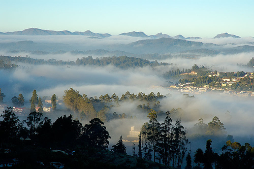
A hill station with a landscape perpetually enveloped in mist, Ooty's beauty has a timeless appeal.

History of ooty
Udhagamandalam, The "Queen of hill station" is one of the best tourist resorts. Nilgiris is called as "Blue Mountains". he name Nilgiri was due to the blue haze which envelopes the range with most distant hills of considerable size.

Places To Visit in OOTY
Government Botanical Garden This garden was laid out earlier by Marquis of Tweedale, the then governor of Madras in 1847. This garden covers an area of 22 acres. A fossil tree trunk of 20 million years is preserved here. The flora of the garden consist of varieties of tree species, grass carpet, variety of ferns, fashioned beds laid beds laid out in an Italian style, multi coloured flowering plants, house ferns and orchids and nurseries.

Lake View
At about one kilometer distance, an artificial lake can be seen with a charming look, which was formed in 1824 by Mr. John Sullivan,the then Collector of Coimbatore. Tamil Nadu tourism Development Corporation provided the following facilities to the tourists.

Mini Garden
Tourists can visit this mini garden which is on the way to the Boat House. The children amusement park is housed here.

Doddabetta
It is the highest peak (2623 meters) in the Nilgiris and is about 10 Kms from Ooty. It lies at the junction of the Western & Eastern Ghats and offer beautiful vistas of the Nilgiri Hill ranges. It is
surrounded by dense sholas. One can have a panoramic view of the landscape

The Mukkurthi Peak & National Park
Mukkurthi Peak is about 40 Kms. form Ooty. The Mukkurthi National Park is located on the Southern corner of the Nilgiris Plateau. The area contains a viable population of Nilgiri Thar (Hamitragus hilocrius). The Kollaribetta and Nilgiris Peak are other major peaks around. The
area is chained by many beautiful and perennial little streams which fall into Bhavani Puzha. The Silent Vally in the Western Ghat is located on the Western side of these ranges. A fascinating feature of the Mukkurthi Sanctuary is its endemism and relationship with Himalayan Flora and fauna.

Hindustan Photo Films
The HPF, one of the major industrial units ot the district, is a public sector enterprise. This unit is located (about 5 Km away from Ooty railway station) over a sprawling area of over 300 acres, near the Ooty golf-links on the Ooty- Mysore road. The HPF was inaugurated by Mrs. Indra Gandhi, Prime Minister, in January, 1967. This industrial unit is currently producing Indu roll films which are used for taking photographs; Indu X-ray films, the quality of which is acknowledged to be among the best in the world; Indu bromide paper on which photographs are printed; and Induaerographic for geological and defence mapping, industrial X - ray film, laser recording film, CAT film, special film for space photography, oscilloscope direct print paper, photo typesetting paper and range of chemicals for the film processing.
Mudumalai Wildlife Sanctuary
This Sanctuary lies at an elevation of 1140 metres in the junction point of Kerala, Karnataka and Tamil Nadu. It however, extends over an area of 321 sq.kms. A variety of habitats ranging from tropical ever green forest, moist teak forest, secondary grass lands and swamps are found. The fauna is varied with Minivets, Hornbills, Fairy Blue Birds, Jungle Fowls, Panther, Sambar, spotted Deer, Barking Deer, Wild boar, Porcupine etc.

Ferhill Palace
Fernhill Palace was the erstwhile summer residence of the Maharaja of Mysore. The first Fernhills bungalow was built in 1844.

Pykara
It is situated about 21 kms from Ooty, on the Ooty-Mysore Road. The tourist attraction are well protected fenced sholas, Toda settlements, undisturbed grassy meadows and also a good wildlife habitat.The Pykara Dam,Pykara falls and the reservoir attracts many tourists.There is a forest Rest House at Pykara. a boat House with Restaurant is available.

Deer Park
It is located at a distance of one Km. on lake road which has Sambar, Chital and Hares besides water birds.

THE NARROW TRAIL
This is a journey nobody should miss. A journey where you jostle with unimaginable crowds and squeeze into tiny coaches, a journey where you feel you can actually reach out and touch the elusive Nilgiris. It starts at Mettupalayam, 46 km southeast of Ooty, where you board the Blue Mountain Express that gets pushed by an engine instead of being pulled! This is a precious travel tip. But once you are on, it' s heaven. The overpowering Nilgiri landscape has the ability to make you oblivious of the human ocean around you and the greenery is bliss. It' s a memorable 4. 5-hour journey, so don' t miss it for anything.

Climate of Ooty
Temperatures range from 25°C in summers to 5°C in the winters.

When to Go to Ooty
Between November and March, avoiding high-season crowds (April-June and September-October).
Wildlife of Ooty-
The region is a treasure of wildlife with some animals even native to these southern mountain ranges. There is that deep-voiced Nilgiri langur (Presbytis johnii) with its shiny black body and yellow-brown crown. The Nilgiri langur happens to be one of the five langur species found in India and Sri Lanka. These langurs of the Nilgiris are often found in the sholas, which are amongst their favourite haunts. It' s in the sholas that you can also see the lion-tailed macaque.

The shy, timid and hard-to-spot Nilgiri tahr (Hemitragus hylocrius) also has its home in these blue mountains. This animal has pride of place in being the only wild goat to inhabit any region south of the Himalayas. It has a short coat, dark yellow brown in color, and prefers to inhabit craggy regions above forest level. The Nilgiris are home to a great variety of carnivorous animals like tigers, panthers, jackals and hyenas. Elephants, wildcats, civet cats, giant squirrels
and mongoose are also part of Nilgiri fauna. The Nilgiri marten, nightjar, hill mynah, and golden oriole are some of the region' s avifauna. In essence, this range of mountains harbors a massive
diversity of animal life.

Ways to Reach to Ooty-
By Air Coimbatore, 105 km from Ooty, is the nearest airport. Indian Airlines has flight to Coimbatore from Bangalore, Cochin and Madras.

By Train The Blue Mountain Express to Ooty is from Mettupalayam (47 km). Mettupalayam can be reached from Coimbatore by the Tea Garden Express.

All important towns of Tamilnadu, Kerala and Karnataka are connected to Ooty.
Reblog this post [with Zemanta]

Thursday, June 4, 2009

Mussoorie "Queen of Hill Stations"


Mussoorie is located in the Garhwal hills, Uttaranchal at a altitude of 2,000 m. Due to its immense natural beauty, Mussoorie is known as the "Queen of Hill Stations".

History of Mussoorie

In 1820, Captain Young from the British army was influenced by the beauty of this place and made this place his residence. This marked the foundation of a hill station called Mussoorie. The name, Mussoorie, is derived from plants of 'Mussoorie' which were found in abundance here. After its discovery, this hill station gradually developed as a center of education, business, tourism and beauty.


Climate & Best Time to Visit

Summers are pleasant in Mussoorie while winters are characterised bysnowfall and rain. Temperature during the summer season lingers around 30 degrees centigrade. During the winters, temperature drops down to near zero at night and remains around 7 degrees at daytime. Mid March to mid November is the ideal time to make a trip to Mussoorie.


Sightseeing in Mussoorie

The Mall : The mainstay of the hill town of Mussoorie, the Mall is a hub of activities from dawn to dusk. The Kulri Bazaar sells interesting souvenirs to take back home. Here, you can also visit
India's largest indoor skating rink.

Gun Hill : A hill that's flat-topped, Gun Hill happens to be the second highest peak in Mussoorie. The spot can be reached from the Mall either on foot or by taking a pony ride. You can also choose to take the 400 metres ropeway which also gives you heart-stirring views.

Clouds End : It is an impressive English country house which was built in 1838 and was also the among the first buildings to be built in Mussoorie. Today, a holiday resort, it gives panoramic views of the surrounding greenery and the snow-laden peaks.
Rice Farming on TerracesImage by treesftf via Flickr


Camel's Back Road : The road which spans over 3 km surrounds the base of the Gun Hill. Tourists arrive here to feast their eyes on thedramatic views of the Himalayan sunset. The place derives its name from a camel-back-shaped rock that lies closeby.
Ven Chetna Kendra - 2 kms from Mussoorie on Tehri bypass is a spectacular picnic spot called Ven Chetna Kendra. It also has park. The whole area is covered with Deodar forests and thick undergrowth. The main attraction of this place has been animals in the park. It can
be accessed by taxi or bus. Municipal Gardens - The municipal or the Company gardens was
previously (before independence) was also known as Botanical gardens of Mussoorie. These gardens were laid by famous geologist Dr. H. Fackner in the last century.

Tibetan Temple - This temple is located in Happy valley area of Mussoorie. Both Company gardens and Tibetan temple can be seen in one day. They are located one kilometer from Lal Bahadur Shastri National Administrative Academy. The Tibetan temple is evidence to rich Tibetan cultural heritage. This temple is sure to attract attention of tourists.

Kempty Falls - Kempty Falls are located 13 kms from Mussoorie. This place was developed as a tourist destination by John Mekinan after 1835.
Nearby Places To Visit

Lake Mist - This place is seven kilometers on way to Kempty Falls.There are good accommodation facilities there for the weary tourists.

Lal Tibba - This place is highest point in Mussoorie. Lal Tibba is located in Landour area which is the oldest inhabited place in Mussoorie.
Yamunotri Bridge:This bridge is located 27 kms from Mussoorie on the Chakrata road. This bridge is famous for fishing.

Nag Tibba which is 55 kms from Mussoorie is very good place for trekking. Nag Tibba, as it is called, is the highest place around Mussoorie. It is surrounded by thick dense forests. The actual trekking for Nag Tibba starts some 21 kms away from the place. The 34 kms journey from Mussoorie is done on Taxi or Bus and the rest is covered on foot. This trek has its own charm and fun. The trek starts at Thathyud.

Bhadraj Temple which is 15 kms from Mussoorie is the place of principle deity of Brother of Lord Krishna, Balram. Every year in the third week of August on Shravan Sankranti day a festival is celebrated here.

Dhanoulti is located 25 kms from Mussoorie on Tehri-Mussoorie highway. Here one has got good accommodation facilities. While going towards Dhanoulti, there are lovely green forest of fur and pine trees. These forests cover the Himalayan ranges lending them an unparalleled beauty. The fresh air and lovely surroundings fills you with enthusiasm and energy.

Sarkunda Devi: This place is 35 kms from Mussoorie. To access this place one has to go till Khaddu Khal by vehicle and then cover 2 kms on foot or on ponies.

Jhari Pani Falls are located some 8.5 kms on the Jharipani-Mussoorie road. 7 kms of the road to these falls is covered by taxi and rest 1.5 kilometers has to be covered on foot.

Activities to Do in Mussoorie

Mountaineering, mountain biking, camping, trekking and nature walks are some popular options to fill your days at Mussoorie with fun, flavour and adventure. Horse riding is another good activity to move around and see the scenic landscapes of the town. Tourists can also
indulge in ice skating at Kulri Bazaar that has India's largest indoor skating rink. Shopping at Kulri Bazaar can get you relics for memories.

Where To Stay in Mussoorie

Accommodation at Mussoorie provides you with an experience which is one of its kind. You need to stay at the town's hotels and resorts to soak up the spectacular panorama. A few of the options include Hotel Green Castle, Hotel Country Inn, Hotel Solitaire Plaza, Hotel Savoy and many more cosy places are there.

Reaching Mussoorie

The Jolly Grant Airport of Dehradun is just 24 km from here and has regular flights from Delhi. From the airport, one can take a bus or a taxi to get to Mussoorie. The railway station at Dehradun (34 km) is also well linked with the key destinations of the country.
The connectivity through roads that link Mussoorie to the important places inside and outside the state is quite good.

Reblog this post [with Zemanta]