Saturday, July 25, 2009

Tawang in Arunachal Pradesh

This is the route that the Chinese soldiers took in 1962 to enter Indian territory. Today known as "the hidden paradise" or "the land of dawn-lit mountains", Tawang is the place if one is looking for a heavenly tryst with nature and a heady mix of history, religion, legends - and Madhuri Dixit.

Arunachal Pradesh


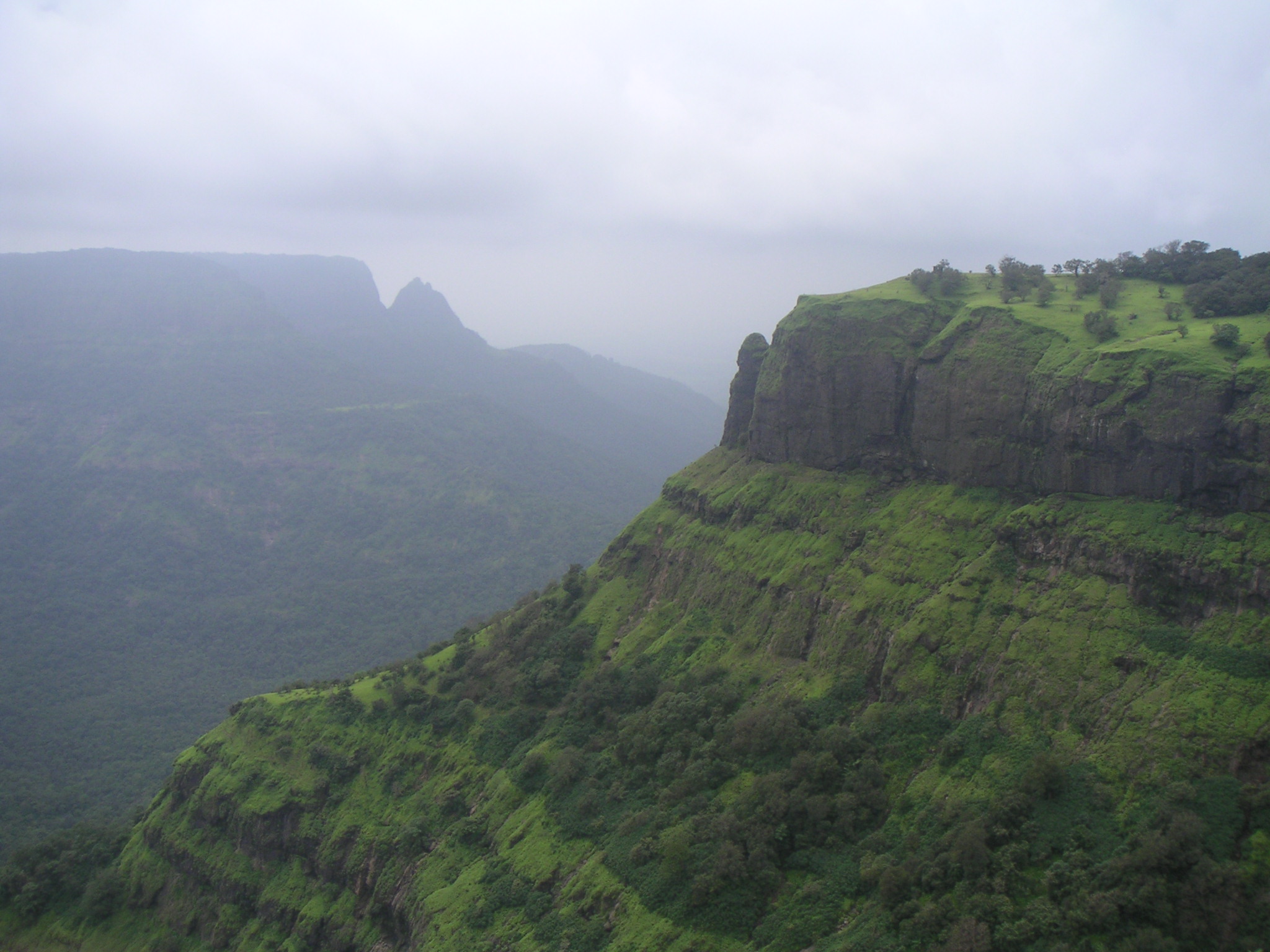
Located on unsurmountable heights of Himalayas at some 3,500 metres above sea level, Tawang is a treat for nature lovers and presents images of virgin mountain forests, exquisite gompas, quaint villages and tranquil lakes.

Complementing the scenic journey is the destination. The Jang waterfalls, locally known as Madhuri falls, are worth a watch. Bollywood actress Madhuri Dixit shot for her film "Koyla" here.

The fifth Dalai Lama, Mera Lama, set out in 1681 searching for a place to construct a monastery. One day after praying for guidance, he found his horse standing quietly on a hilltop and took it as a divine sign. Hence the name Tawang, which means chosen by the horse.


Arunachal Pradesh

The major attraction of the place is the Tawang monastery, one of the largest Buddhist monasteries in India; an all-women monastery and Madhuri waterfalls, named after the Bollywood actress who came here on a film shoot.

The 400-year-old hilltop Tawang monastery is built like a fortress and is home to around 600 lamas. It has dormitories, a meeting hall, school, community kitchen, monuments and the main building housing the temple - Dukkang. With its narrow cobbled streets, numerous buildings and the enormous area it occupies, the gompa is like a mini city.


"Locals helped build the monastery and even today they are responsible for looking after it," said a monk, as others chanted softly in the quiet mountain air.

Inside the monastery, the huge 30-foot Buddha statue made of wood sits serenely amidst priceless tankhas (scroll-paintings) and Buddhist artefacts. Attached to the gompa is a museum which displays ancient manuscripts and precious artefacts, evocative of the centuries-old India-Tibet Buddhist trail.

The monastery has recently undergone renovation and bright paintings adorn its walls. Dances and ceremonial celebrations are held in the courtyard, the most important of which is held on the night of Buddha Purnima, the full moon night on which the Buddha was born, attained enlightenment and died.

A few kilometres away is the Thukje Chueling Nunnery run by female monks, home to around 50 of them. Only women are allowed to stay inside the monastery.

To reach Tawang, you drive for 12 hours from Assam's Tezpur town, a major Indian Air Force base. The road is a visual delight with clouds sometimes literally descending to the ground and ravines breaking the monotony of virgin forests straddling the commanding mountains.

The Indian Army war memorial at Jaswant Garh is another must visit. Dedicated to the martyrs of the 1962 India-China war, the memorial is nestled among mountains overlooking the Tawang-Chu valley.

Though China still claims Tawang is within its territory, the area is peaceful and is not affected by insurgency.

Despite increasing flow of tourists to Arunachal Pradesh, Tawang remains largely unexplored and poor roads can make the journey a really long one. Tourists also need to plan in advance, as inner line permits are needed to visit some areas in and around Tawang.


Reblog this post [with Zemanta]

Monday, July 20, 2009

Mount Abu - Rajasthan

Mount Abu is the only hill station of Rajasthan. Mount Abu is present amidst the rocks on a 1,220-m granite table mountain at the far southwestern end of the Aravalli hills. It is built around a lake and is surrounded by forested hills.The famous place derives its name from Arbuda, a serpent who descended to the spot to rescue Shivji’s bull, Nandi.

r
Mount Abu

Besides having all the features of a pleasant hill area, Mount Abu is also well known for the famous Dilwara temples and many more archaeological remains. There are interesting treks and picnic spots, romantic royal retreats of the various erstwhile families of bygone Rajputana and some relics of the Raj period.

The scenic landscapes include gigantic blocks of rocks in weird shapes, an array of coniferous trees, flowering shrubs, lovely lakes and the cool climate much in contrast to the otherwise arid environment of the state.

Prime Attractions of Mount AbuGovt. Museum - Mount Abu. The museum was set up in 1962 within the premises of Raj Bhawan to preserve the archaeological wealth of the region.

Mandakini Kund
The watersupply for Achalgarh fort and a sculpture of Parmar Daravarsh are situated close to the Achaleswar Mahadev temple.


Mount Abu

Nakki Talav
This holiday centre of Mount Abu, is virtually in the heart of the town. This sparkling blue artificial lake is said to have been gauged from the earth by the gods, using their fingernails ('nakh' means nail). Nearby is the 14th century Raghunath Temple. On the western edge of the town centre, Nakki Lake Road circles the entire lake. Rowing boats are available for hire from the jetty by Gandhi Park.

Dilwara Temples
This complex consisting of five marble Jain temples is one of the finest in Rajasthan, worth braving the queues and ferocious guards. These beautifully carved temples built between 11th & 13th century AD are sheer elegance in marble, dedicated to the Jain Tirthankaras.

The Vimal Vasahi Temple is the oldest of these, dedicated to the first Tirthankara. Built in 1031 AD (by Vimal Shah- a merchant and representative of the then Gujarat ruler), it is a superb example of temple architecture.

Mount Abu


Gaumukh Temple
Dedicated to Rama, this small temple (the cow’s mouth) is centered on a spring gushing from the mouth of a marble cow. In the Hindu creation myth, the world is formed by a cow, licking salt; the source of the Ganges has the same name. This is said to be the site of the ancient 'Agnikund' fire rituals. It is 4 kms south of Mount Abu.

Summer Festival
The Summer Festival is held every year in the month of Aashadh (June) in Mt.Abu. The steep rocks, tranquil lakes, picturesque locations and the pleasant climate of Mount Abu make it an ideal location for the festival.

Various Points in Mount Abu
Several points around the edge of the plateau offer spectacular views across the plains. The best are Honeymoon Point (Anadra Point) and Sunset Point, where hundred of people gather to watch the sunset every evening in a carnival atmosphere of pony rides and souvenir sellers.

Achalgarh
An impressive fort with some beautiful Jain temples enclosed within. Among the noteworthy temples are Achaleswar Mahadev temple (1412 AD) and Kantinath Jain temple (1513 AD). The latter has a gold plated image. The fort was built in the 14th century AD by Rana Kumbha and is approachable by a motorable road. An impressive fort with some beautiful Jain temples enclosed within. Among the noteworthy temples are Achaleswar Mahadev temple (1412 AD) and Kantinath Jain temple (1513 AD).

The fort was built in the 14th century AD by Rana Kumbha and is approachable by road.

Adhar Devi Temple
This ancient temple dedicated to the serpent goddess, Arbuda, is carved out of a huge rock.. Arbuda is the patron of the town, who formed the mountain in order to save the sacred cow, Nandi from drowning in an abyss. The black-painted marble idol, riding a solid gold tiger, is claimed to be about 5,000 years old. Open and free access during daylight hours.

Mount Abu


Guru Shikhar
The highest peak on the Mount Abu (1722 metres above the sea level) allows a bird’s eye view of the idyllic surroundings of Mt. Abu. A small shaivite shrine and a temple of Dattatreya standing on the Shikhar are worth a visit.


Trevors Tank

Named after the British engineer, who constructed it, Trevors tank is a delight for birdwatchers with densely wooded hills that are a haven to pigeons, peacocks and partridges.

How to Get There - Mount Abu
By Air
The nearest airport to Mount Abu is Maharana Pratap Udaipur Airport, Dabok (Udaipur) 207-km. One can hire a taxi to get to Mount Abu.

By Rail
The nearest railway station is Abu Road (29-km) situated on Mumbai-Ahmedabad-Ajmer-Jaipur-Delhi route. From Abu Road one can take a taxi, jeep or bus to Mount Abu.

By Road
Ahmedabad is 222-km via Palanpur. Jodhpur is 235-km via Sirohi and Pali. Udaipur is 156-km via Pidwara. (Journey on this route is advisable only during the day). Jaipur is 509-km via Pali-Ajmer. It is connected to all the major towns in northern and western India

Local Transport
Taxis are available for local transportation within the city.

Shopping - Mount Abu
Where to Shop
Curios in marble, sandalwood and sandstone can be bought from the shops around Nakki Lake. Kota saris, bangles and linen with Sanganeri prints are also available. For Rajasthani Handicrafts there is Rajasthali, Rajasthan Government Handicrafts Emporium and Khadi Bhandar.

Saturday, July 4, 2009

Saputara A Hill Station of Gujrat


Saputara is raw, picturesque and a densely wooded only hill station town situated in the "Dang" district of southern tip of Gujarat, India.

Saputara has been constructed as a well planned hill station having all necessary services like hotels, boating parks, swimming pools, club, ropeways, theaters and a museum providing the tourists an delightful vacation in the coziness of the hill station.

The big Gujrat cities closest to Saputara are Surat, 170 Kms from there and Nashik, 80 Kms away. The border of Maharashtra is about 5 kms. away from Saputara.

This hill station is situated on a plateau in the Dang forest area of the Sahyadri Hills Range. At an altitude of around 1,000 m with a climate that is pleasant although bit cold, throughout the year, Saputara literally stands for "Abode of Serpent". There is a presence of snake sculpture on the shores of Sarpagana River which flows through the town. This snake sculpture on the shores of Sarpagana River is worshiped by the local tribes on many festivals like Holi.

Tribes like Kunbis, Warlis, Bhils and Gamits inhabit Dangs. They are known for their traditional dances, which are performed wearing Bamboo and Wooden masks. The dangs district constitute of an area of 1,752 km. having population of 1.5 lacks with a tribal population density of 94% and located in south-east of Gujarat.

Sight Seeing in Saputara

There are some worth-watching places to enjoy your holiday in Saputara town. Those lookout places or places of interest are: Ropeway, Sunset Point, Sunrise Point, Boating Club, Museum, Step Garden, Rose Garden, Honey Bees Centre, Echo Point, Lake View Garden, Snake of Saputara etc. and some other religious attractions.


Saputara Lake
This is one of those places where you can breathe unpolluted air while enjoying your holiday out of the hustle and bustle of polluted city life. You can even go for a trekking down to nearby villages. No local transport is that much available in this hill station and this
tourist's or trekking place can be best covered on foot.

Excursion tours from Saputara

Saputara is best known for its wildlife excursion tours. Saputara is rich in wildlife resources and scenic beauties. Some of the scenic beauties include Botanical garden, Gira falls, Mahal forest, Unnai Mata Temple & Hot Spring, Jambalaya, Girmal Falls, Dang Darbar, Hatgadh Fort, Saptashringi Devi Mandir etc.

Climate & Weather of Saputara

The hill station Saputara refreshes the tourists throughout the year with its cool and cozy weather. Any rough temperature variation is not seen in Saputara. Saputara is a prototypical example of general and wildlife excursion tourists" destination for the pollution hit and heat-scorched lives of the plains and metros.

Accessibility of Saputara

By Road: State transport buses end private luxury coaches are available from various centers of Gujarat and Maharashtra for to and fro journey from there to Saputara. Different distances to Saputara are mentioned below.

By Rail:
Nearest Railway Station from Saputara is Nasik Road (80 kilometers-Central Railway), and Billimora (112 kilometers-Western Railway). Nearest narrow gauge railway station is Waghai, it is in the narrow gauge section of the Western Railway. For the travelers coming from Gujarat via Ahmedabad or Surat or even from Mumbai, Billimora is the most convenient railway station as sufficient direct bus is available from there to Saputara.

By Air: Nearest airport is Mumbai, 265 kilometers away.
Reblog this post [with Zemanta]

MATHERAN


This sparsely populated place at an altitude of 800 meters is a picturesque hill station called Matheran Hill Station, near to Mumbai at 104 kms. It is an undulating hilltop cloaked in shady trees and ringed by walking tracks leading to look outs that drop sheer to the plains. Matheran is situated in the Matheran range of Sahyadris at a height of 2516 feet.

Matheran truly is Maharashtra's one of the most beautiful and well maintained hill station. The availability of road and railway have made it accessible to all people irrespective of their age. The ban on motor vehicles inside Matheran have helped to preserve its ecology and keep intact its natural beauty.

Matheran has 38 points at which can get a glimpse of nature's beauty. However, to cover most of these points requires atle
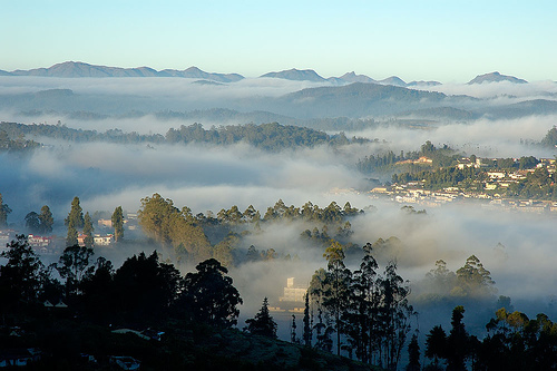
ast one night stay in Matheran. Point seeing in Matheran is quiet easy due to the presence of sign boards and map. Maps are also easily availbale in Matheran and can be used to plan your point seeing. Given below are few points which we shouldn't miss.

Echo point offers a panoramic view and allows you to enjoy the echo's.

King George point
A must visit point in monsoon as it offers a beautiful view of the waterfall formed by the water overflowing from Charlott Lake. One can even reach he mouth of the waterfall with care, strong wind prevents the water from falling down and throws it back.

Charlott Lake
It's the only water source atop Matheran that it provides water to entire Matheran.
Louisa Point
It offers a beautiful face on view of the waterfall seen from the King George point.

Panorama point
Although quiet far from Bazapeth it gives you a panoramic view(that's why it's named as Panorama point) of the Sahyadri ranges


Even the bazaar is just that a small marketplace, not a commercial shopping complex. It runs the length of one street, and contains shops and stalls that sell the produce of Matheran. You can see workmen hunching over strips of leather, fashioning the Kolhapuri chappal that Matheran is famous for. Leather bags, leather belts, leather shoes& the workmanship is exclusive and the prices reasonable. There are also glass birds and dried wild flowers for sale that have a quaint appeal.

One other thing that dominates the market is chikki, a confection made of gram flour, jaggery and cashew nut. You could buy chikki in kilos to carry home; it is a universally popular sweetmeat.

The presence of hotel's and lodging boarding facilities have made it possible to have a multi-day stay in Matheran and thoroughly enjoy nature's beauty. The modes of transport in Martheran are limited to horses and rickshaws (pulled by humans), however seeing the various points in Matheran by walking is equally enjoyable.

To reach Matheran one has to first reach Neral. Neral is well connected to Mumbai by rail and road. From Neral Matheran can be reached by a narrow gauge railway or by taxies. Railway function normally in summer and winter sseason but there is only one train to Matheran in winter.The nearest airport is Mumbai that is around 100 kms from there. Neral 21 kms. away, is where you board to the toy train. Taxis are available from Neral to Dastoori car park. No vehicles are allowed inside Matheran and ponies are the favoured means of transport.
Reblog this post [with Zemanta]

OOTY - Spectacular Place!


Ootacamund is a popular hill station located in the Nilgiri Hills of Tamil Nadu, India. Udhagamandalam is the official Tamil name for the town. Ooty stands at an approximate height of 9,080 feet (2,268 m) above sea level.

Nestled in the brilliant green hills of the Nilgiris, its one of the favourite summer retreats of people in South India or the whole of India. Orchards of peaches and plums, terraced tea plantations, and eucalyptus, pine and wattle lining the landscape… a typical hill station in many ways. Founded by the British in the early part of the 19th century, Ooty was home to many Britishers who have fallen in love with this hill station where they discovered a little bit of England.such as beautiful English rain. The British influence is visible in the handrolled cigars, chocolate and cheese one enjoys here.

A hill station with a landscape perpetually enveloped in mist, Ooty's beauty has a timeless appeal.

History of ooty
Udhagamandalam, The "Queen of hill station" is one of the best tourist resorts. Nilgiris is called as "Blue Mountains". he name Nilgiri was due to the blue haze which envelopes the range with most distant hills of considerable size.

Places To Visit in OOTY
Government Botanical Garden This garden was laid out earlier by Marquis of Tweedale, the then governor of Madras in 1847. This garden covers an area of 22 acres. A fossil tree trunk of 20 million years is preserved here. The flora of the garden consist of varieties of tree species, grass carpet, variety of ferns, fashioned beds laid beds laid out in an Italian style, multi coloured flowering plants, house ferns and orchids and nurseries.

Lake View
At about one kilometer distance, an artificial lake can be seen with a charming look, which was formed in 1824 by Mr. John Sullivan,the then Collector of Coimbatore. Tamil Nadu tourism Development Corporation provided the following facilities to the tourists.

Mini Garden
Tourists can visit this mini garden which is on the way to the Boat House. The children amusement park is housed here.

Doddabetta
It is the highest peak (2623 meters) in the Nilgiris and is about 10 Kms from Ooty. It lies at the junction of the Western & Eastern Ghats and offer beautiful vistas of the Nilgiri Hill ranges. It is
surrounded by dense sholas. One can have a panoramic view of the landscape

The Mukkurthi Peak & National Park
Mukkurthi Peak is about 40 Kms. form Ooty. The Mukkurthi National Park is located on the Southern corner of the Nilgiris Plateau. The area contains a viable population of Nilgiri Thar (Hamitragus hilocrius). The Kollaribetta and Nilgiris Peak are other major peaks around. The
area is chained by many beautiful and perennial little streams which fall into Bhavani Puzha. The Silent Vally in the Western Ghat is located on the Western side of these ranges. A fascinating feature of the Mukkurthi Sanctuary is its endemism and relationship with Himalayan Flora and fauna.

Hindustan Photo Films
The HPF, one of the major industrial units ot the district, is a public sector enterprise. This unit is located (about 5 Km away from Ooty railway station) over a sprawling area of over 300 acres, near the Ooty golf-links on the Ooty- Mysore road. The HPF was inaugurated by Mrs. Indra Gandhi, Prime Minister, in January, 1967. This industrial unit is currently producing Indu roll films which are used for taking photographs; Indu X-ray films, the quality of which is acknowledged to be among the best in the world; Indu bromide paper on which photographs are printed; and Induaerographic for geological and defence mapping, industrial X - ray film, laser recording film, CAT film, special film for space photography, oscilloscope direct print paper, photo typesetting paper and range of chemicals for the film processing.
Mudumalai Wildlife Sanctuary
This Sanctuary lies at an elevation of 1140 metres in the junction point of Kerala, Karnataka and Tamil Nadu. It however, extends over an area of 321 sq.kms. A variety of habitats ranging from tropical ever green forest, moist teak forest, secondary grass lands and swamps are found. The fauna is varied with Minivets, Hornbills, Fairy Blue Birds, Jungle Fowls, Panther, Sambar, spotted Deer, Barking Deer, Wild boar, Porcupine etc.

Ferhill Palace
Fernhill Palace was the erstwhile summer residence of the Maharaja of Mysore. The first Fernhills bungalow was built in 1844.

Pykara
It is situated about 21 kms from Ooty, on the Ooty-Mysore Road. The tourist attraction are well protected fenced sholas, Toda settlements, undisturbed grassy meadows and also a good wildlife habitat.The Pykara Dam,Pykara falls and the reservoir attracts many tourists.There is a forest Rest House at Pykara. a boat House with Restaurant is available.

Deer Park
It is located at a distance of one Km. on lake road which has Sambar, Chital and Hares besides water birds.

THE NARROW TRAIL
This is a journey nobody should miss. A journey where you jostle with unimaginable crowds and squeeze into tiny coaches, a journey where you feel you can actually reach out and touch the elusive Nilgiris. It starts at Mettupalayam, 46 km southeast of Ooty, where you board the Blue Mountain Express that gets pushed by an engine instead of being pulled! This is a precious travel tip. But once you are on, it' s heaven. The overpowering Nilgiri landscape has the ability to make you oblivious of the human ocean around you and the greenery is bliss. It' s a memorable 4. 5-hour journey, so don' t miss it for anything.

Climate of Ooty
Temperatures range from 25°C in summers to 5°C in the winters.

When to Go to Ooty
Between November and March, avoiding high-season crowds (April-June and September-October).
Wildlife of Ooty-
The region is a treasure of wildlife with some animals even native to these southern mountain ranges. There is that deep-voiced Nilgiri langur (Presbytis johnii) with its shiny black body and yellow-brown crown. The Nilgiri langur happens to be one of the five langur species found in India and Sri Lanka. These langurs of the Nilgiris are often found in the sholas, which are amongst their favourite haunts. It' s in the sholas that you can also see the lion-tailed macaque.

The shy, timid and hard-to-spot Nilgiri tahr (Hemitragus hylocrius) also has its home in these blue mountains. This animal has pride of place in being the only wild goat to inhabit any region south of the Himalayas. It has a short coat, dark yellow brown in color, and prefers to inhabit craggy regions above forest level. The Nilgiris are home to a great variety of carnivorous animals like tigers, panthers, jackals and hyenas. Elephants, wildcats, civet cats, giant squirrels
and mongoose are also part of Nilgiri fauna. The Nilgiri marten, nightjar, hill mynah, and golden oriole are some of the region' s avifauna. In essence, this range of mountains harbors a massive
diversity of animal life.

Ways to Reach to Ooty-
By Air Coimbatore, 105 km from Ooty, is the nearest airport. Indian Airlines has flight to Coimbatore from Bangalore, Cochin and Madras.

By Train The Blue Mountain Express to Ooty is from Mettupalayam (47 km). Mettupalayam can be reached from Coimbatore by the Tea Garden Express.

All important towns of Tamilnadu, Kerala and Karnataka are connected to Ooty.
Reblog this post [with Zemanta]