Saturday, May 30, 2009

Pithoragarh -Serene & Spiritual


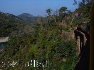
Pithoragarh is in the inner Himalayas at a height of 1,851 meters in a spectacular valley situated in the northern state of Uttaranchal. The town lay on the old trade route to Tibet and is still en route the sacred trail to Mount Kailash and Lake Mansarovar.This not so popular
part of Kumaon is very picturesque and is often referred to as ‘Mini Kashmir’.

Before 1960, Pithoragarh was a part of district of Almora and became a separate district in the same year.

Serene & Calm - Pithoragarh

Pithoragarh is rich in natural beauty and it offers best view of the Himalayan peaks. Some of the peaks like Nanda Devi ,Panchchuli ,Trishul , Nandakhat falls in this district. District pithoragarh has some finest glacires in the world such as Milam Glacier,Sunder Dhunga Glacier, Ralam Glacier, Namik Glacier.Pithoragarh has a cool climate which makes it comfortable all year round.

Lakes of Pithoragarh

There are a number of lakes in and around Pithoragarh. Two of them, Jolingkong and Anchherital are situated at a height of 4,634 meters and 3,658 meters, respectively.

Temples of Pithoragarh

Some beautiful old temples are also scattered around the district. A visit to the shrine at Purnagiri, 20 kilometers from Tanakpur, is believed to lead to fulfillment of one' s desires. There is also a Sikh shrine near Lohaghat called Ritha Sahib, associated with the visit of Guru Nanak. It is believed that the bitter ritha turned sweet after the touch of the Guru.

Champawat

76 kms from Pithoragarh at an altitude of 1615 mts is Champawat, the erstwhile capital of the Chand Rajas of Kumaon. The ancient fort now houses the Tehsil offices. The site of several shrines, the principal temple here is the Nagnath temple. A tourist bungalow is available for
accomodation.

Devidhura

45 kms from Lohaghat lies Devidhura at a height of 2500 mts. It is the site of the famous temple of Barahi Devi, and also the venue of a grand fair on the occasion of Raksha Bandhan.

Kali Temple(Gangolihat)

Gangolihat, an important religious site, lies 77 kms from Pithoragarh. At the ancient Kali temple, a colourful fair is held during Navratris. The famous Patal Bhuvneshwari caves are located 14 kms away. PWD and Zila Parishad Dak Bungalows are available for accomodation.
Chaukori

112 kms from Pithoragarh is picturesque Chaukori which boasts a splendid view of the Himalayas. Tourist rest house is available.

Punyagiri Temple

Punyagiri temple is one of the most renowned temples in the Kumaon region. Lakhs of pilgrims visit the shrine during April to June. The site is around 20 kms from Tanakpur, out of which 6 kms is to be trekked. A tourist bungalow and dharamsalas are available for accomodation.It is held in great reverence.

Jaul Jibi

68 kms from Pithoragarh, Jaul Jibi is the venue of a grand fair, held every year at the confluence of the rivers Gori and Kali, in the month of November, which attracts people from neighbouring Nepal too. Ritha-Saheb: A major Sikh pilgrimage site, Ritha-Saheb lies 62 ks from Lohaghat. Accomodation facilities are provided by the Gurudwara authorities.
Rameshwar

36 kms from Pithoragarh is Rameshwar, located at the confluence of the Ram Ganga (East) and Saryu rivers. It is the site of a Shiva temple, where a huge fair is held every year on Makarsankranti (January).

Glaciers of Pithoragarh
Milam Glacier

This majestic glacier lies 208 kms from Pithoragrah. From Munsiyari one has to trek for 54 kms. Rest Houses are available enroute.
Munsiyari

Munsiyari lies 154 kms from Pithoragarh enroute to Milam Glacier. Perched at an altitude of 7000 feet, Munsiyari commands a fascinating view of the Panchchuli Range and Gori river. It also forms the base for treks to Milam, Namik and Ralam glaciers. Munsiyari is also the
venue of numerous fairs during August and September. Tourist rest house is available for accomodation.

Shyamla Tal

132 kms from Pithoragarh is Shyamla Tal, a beautiful natural lake at the bank of which is located Swami Vivekananda Ashram where accomodation facilities are available on request.
Chhota Kailash

Kailash Mansarovar Yatra Route: The Kailash Mansarovar Yatra is conducted by the Kumaon Mandal Vikas Nigam. The road journey for this Yatra concludes at Tawaghat near Dharchula. From this point pilgrims have to trek through the valley of Kali (Sharda river). Campsites are
centred arond Narayanswamy Ashram, Sirkha, Budi, Gunji, Navedhang and Kalapani. From Gunji (3500 mts) there is a diversion to Kuti valley which leads to Chhota Kailash through the village of Kuti. Nearby Places to Pithoragarh Baleshwar

This is 76 kilometers from Pithoragarh on the Tanakpur road. Its temples are the best examples of hill architecture. They were constructed by the early Chand rajas in the 8th century. At Gangolihat, 77 kilometers from Pithoragarh, is a Shakti peeth established by Adi Shankaracharya. The temple stands amidst a dense deodar forest. Two kilometers away is another temple that of Chamunda Devi. It is believed that the evil forces conquered by the Goddess still dwell in the adjoining caves. Patal Bhubaneshwar, a temple dedicated to Lord Shiva is 14 kilometers from Gangolihat. The way to the temple is through a tunnel. Chemical reactions in the cave have given rocks the appearance of various Gods and Goddesses.

Chandak

It is 7 km from Pithoragarh, is a beautiful location, commanding a panoramic view of the Pithoragarh valley. It is 1.830 meters in altitude. An important fair is held at the Mostmanu temple in August. Thal Kedar, 16 km, from Pithoragarh is an important religious center and also noted for its natural beauty. A large fair is held on Shivratri. Dhwaj, 28 km from Pithoragarh, commands a wide view of the majestic snow-peaks of the north. It is also important for temples
devoted to Lord Shiva and Maa Jayanti.
Champawat

It is 76 km from Pithoragarh, was once the capital of Chand Rajas, whose fort now houses a government office, the town has many architecturally beautiful temples. Of these, Baleshwar and Nagnath temples are noteworthy. Kumaon Mandal Vikas Nigam maintains a tourist bungalow at Champawat. At 2,500 meters above sea level, Devidhura is known for its scenic beauty and temple of Devi, site of an important fair. 14 km from Gangolihat is Patal Bhuvaneshwar, an important archaeological and religious site.

Askot Wildlife Sanctuary

Askot Sanctuary, established in 1986, is located in the pastoral surroundings of Indo-Nepal border, in Pithoragarh.

The best time to visit this heaven like hill station is from April to
June & September to October.
Reblog this post [with Zemanta]

Kufri Small Delight of HP


Kufri is a small hill station in Shimla district of Himachal Pradesh state in India.

Location

It is located 13 km from the state capital Shimla on the National Highway No.22. Kufri has a Himalayan Wild Life Zoo which hosts rare Antelopes, Felines and Birds including Himalayan Monal, the state bird of Himachal Pradesh. During winter a meandering path through the potato plantations turns into a popular Ski track.

History

The region around Shimla including Kufri was once a part of the Kingdom of Nepal until the area was ceded to the British Raj as part of the Sugauli Treaty. This region remained obscure from the rest of the world until the British 'discovered' it in 1819.

Places of interest

Among the famous sight-seeing places are mentioned here.

Mahasu Peak

One can hike through thick forest around Kufri to the Mahasu Peak- the highest peak in Kufri.

Indira Tourist Park

The Indira Tourist Park is near the Himalayan Nature Park and provides panoramic view of the locations around.

The best time to visit is April to June & November to February.
Reblog this post [with Zemanta]

Saturday, May 23, 2009

Chail Hill Station

Chail is honeymooners paradise, a hill station of Himachal Pradesh.

Chail Hill Station

It is situated at a height of 2,250 m above the sea level. Bhupinder Singh, Maharaja of Patiala, when was facing an exile from Shimla, he decided to create his own summer capital, which was Chail.

Chail was perfect sometime in history and so it is now - it was surrounded by a thick cover of majestic, soaring deodars, Simla was just 45 kms away, and most significantly, the hill of Chail was decidedly higher than the then British-controlled Shimla.

The picturesque hill station is located amidst scented forests of chir pine and gigantic deodars. Chail is built on three hills, the palace is on Rajgarh Hill, the Residency Snow occupied by British resident is on Pandhewa Hill and on the third hill Sadh Tiba where Chail is situated. Overlooking Satluj Valley, Shimla and Kasauli are also visible at night from here.

Chail has the highest cricket ground in the world, well-kept and well maintained lush green ground is surrounded by massive deodar and pine trees. On the other side of the town are situated the massive Himalayan ranges spectacularly gleaming in the sun and snow-covered every thing under it.

Chail has a natural air-conditioned weather and the tourist find this place to be suitable to visit all throughout the year. Even during the summer the temperature doesn't rise to much, the autumn in all its colors is really fascinating. During autumn, the fields and the forests are covered with a cloak of russet and gold and in winter it is nothing less than a paradise. The weather conditions are so perfect that even in the winter when there is snow fall there is an unusual featured warmth present avoiding the inconvenience of the people. Sight seeing in Chail

Chail Sanctuary

Chail is always splurging with numerous tourists. The Deodar and Oak forests with grasslands around the township are the abode of wildlife.Chail sanctuary was notified on 21st March, 1976 near Chail Town in District Shimla and covers an area of 10,854.36 hectares.

Palace Hotel

The little 'hill station' of Chail came into being when Bhupinder Singh, Maharaja of Patiala was banished from Shimla, the 'summer capital' of British India, after a dalliance with the
Commander-in-Chief's daughter in the late 19th century.

Cricket Ground

Surrounded by gigantic deodar and well maintained Chail Cricket ground is the highest cricket ground in the world. Built in 1893, this cricket pitch located at the height of 2,144m is also used as polo ground.

Maharaja's Palace

The magnificent Rajgarh palace, with elaborate furnishings, built in 1891. With comfortable log huts and cottages, dense forests and serene walks, sprawling lawns, a childrens park, a `lovers hill', and sports facilities, Chail is a resort in the real sense of the term.

Sidh Baba Ka Mandir

Maharaja Bhupinder Singh had originally intended this to be the site of his palace, and had even started building it, but as is believed, a 'sidh', saintly person appeared in the Maharaja's dream, and declared that this was the place where he had meditated. Consequently, Bhupinder Singh shifted his venue and built a temple on the spot.

On the outskirts of Chail there are other good places to visit like Kufri, another hill-station and Sadhupul, a picnic spot.
Reblog this post [with Zemanta]

Wednesday, May 13, 2009

Kangra - A Valley to Watch


Kangra Valley is located in the western province of the state of Himachal Pradesh, India. It is 18 km south of Dharamshala and is one of the prettiest valleys of Himachal with its lush green terraces & orchards, overlooking a gushing stream - the Banganga.

Kangra valley routes out near Mandi, runs north, then bends west and extends to Shahpur near Pathankot.

The valley, sheltered by the sublime Dhauladhar range, is green and luxuriant. The area around Kangra is known for its old temples and serene surroundings and as a centre of the arts. Despite the onslaughts and political upheavels, the arts and crafts of the region continued to develop and found lyrical expressions. Crafts like the exquisitely designed shawls and miniature paintings of this region are internationally appreciated.

There are several tea gardens dedicated to the production of both green and black tea. The people of the valley are well built and are known for their dedicated services to the nation as soldiers. Kangra Valley, is an ideal place for adventure and sports activities like mountaineering, trekking, rock climbing and fishing , it is this valley which witness annually Hang-gliding rally.

Topography of the region allows existence of many peaks between 3500 m to 5000 m in Dhauladhar ranges. Most of the treks are operational from May to October. Pilgrims flock to Kangra in the month of April for the Navratra celebrations, and in September-October, before the Dussehra festival, to pay their homage to Goddess Durga at the Vajreshwari (Kangra Devi) temple.


Weather

The weather in Kangra is alpine. Summers (April-June) are mild and winters are cold (November-February). It experiences south-west monsoon rains in July-September. The Kangra region receives the second highest rainfall per annum. The best time to visit Kangra is between March and June.
Places to Visit in Kangra

There are many a attractions in the green picturseque valley to pay a visit. These include Brajeshwari Devi Temple, Kangra Fort, Maharana Pratap Sagar, Kangra Art Museum, Masroor, Dharamshala , Jwalamukhi Temple, Pong Dam Sanctuary.

Kangra Fort

This ruined historical structure, Nagar Kot is located 2.5 km south of the town, perched on a high windswept ridge. One can enjoy the panoramic view of the surroundings, which includes the confluence of Manjhi and Baner rivers from its top.

Maharana Pratap Sagar Dam
Named in honour of the great patriot Maharana Pratap (1572-97 AD), over the river Beas, the Pong dam was completed in 1976. Its reservoir covers an area of about 45,000 hectares at maximum possible flooding.The level varies every season and averages around 30,000
hectares. Over 200 villages with a population of over 85000 people lie along the wetland. The lake is well served by a network of roads.
Kangra Art Museum

This museum has miniature paintings from the Kangra school of art, which flourished in the Kangra valley during the 17th century, it also has elaborately embroidered costumes of Kangra people, woodcarvings and tribal jewellery

Jwalamukhi Temple

The famous temple of Jwalamukhi is 30kms. from Kangra and 56 kms from Dharamshala. Dedicated to the "GODDESS OF LIGHT", the temple is one of the most popular Hindu temples in northern India. There is no idol of any kind the flame is considered as a manifestation of the goddess. An eternally burning and shining blue flame emanates from the rock sanctum and is fed by the priests with the offerings of devotees. The golden tower (dome) of the temple was a gift from the Emperor Akbar.

Masroor

Known for its monolithic rock temples, Masroor is 15kms. south of Kangra. There are 15 rock cut temples in Indo-Aryan style and richly carved. The temples partly ruined now are profusely decorated with sculptural ornamentations , conceived in the same manner as the great temple of Kailash at Elora in Maharastra with which they bear a striking resemblance. The main temple is dedicated to Lord Ram, Lakshman and Sita.

Pong Dam Sanctuary

Pong Dam Sanctuary, the lake, created by damming the Beas River in 1976, lies in Kangra District on the border with Punjab State. The area under this Sanctuary is 32,270ha using digitised maps. The lake level fluctuates between 335m and 436m. All land above 440m within a 5km radius of the lake (an area of about 20,000ha) is notified as a buffer zone. Pong Dam Sanctuary lies between the outer Siwaliks and Daula Dhar, Pong Dam is the largest standing water body in Himachal Pradesh and covers about 7,000ha at its maximum extent. It includes
one permanent island (Ransar) and several others that are periodically connected to the shore. Five perennial streams flow south-west into the reservoir, namely Bul Khad, Dehr Kad, Dehri Kad, Gaj Khad and Baner Kad. Conditions are monsoonal, with hot humid summers and cool,
dry winters.
Brajeshwari Devi Temple

Just outside the town is the temple dedicated to Brajeshwari Devi. It was completely devastated in 1905 by an earthquake and then was rebuilt in 1920. A large number of devotees gather in the temple premises during various Hindu festivals.


To reach Kangra that is 170 km from Chandigarh, 110 km from Amritsar, 55 km. from headquarters at Dharamshala, the closest railway stations are at Mukerian 30 km, and Pathankot at 32 km. The closest airport is Gaggal 40 k.m.
Reblog this post [with Zemanta]

Friday, May 8, 2009

Hill Station Dharamsala


Dharamsala is a hill station in Himachal Pradesh, famed for its large Tibetan community centered around the Dalai Lama.

The Tibetan Buddhist roots of Dharamsala stretch back into the 8th century. "Dharamsala" literally means an "inn attached to a temple", and it was so until the district headquarters in Kangra became too crowded and the British moved two of their regiments in the late 1840s
to what is now Dharamsala.

This over the years grew to be district headquarters of Kangra, and the very location is now known as the Police Lines.

Currently, it is a very popular hang-out for foreigners and students of Buddhism. Indeed, it is now perhaps a little too popular - many would say the town (esp. McLeod Ganj) is little more than a backpacker ghetto. Don't come here expecting calm and tranquillity.
Tsuglagkhang Complex, Temple Road. This is the largest Tibetan temple outside Tibet, and it has a large meditation hall containing some beautiful statues and thangkas, as well as a Kalachakra temple with beautiful murals. It is the monastery of His Holiness, the Dalai Lama, and is located just in front of his residence. On the basement level of the complex you will also find the Namgyal Cafe, which is run as a work-training center for Tibetan youth
with daringly fusionesque if often unremarkable food, but great atmosphere in the evenings.

Tibet Museum
Small but interesting museum on the history of Tibet and its people.

Tibetan Library, near the Tibetan Government in Exile, with a small but interesting museum.

Tibetan Institute of Performing Arts (TIPA). Stages performances of traditional Tibetan dance, music, and theatre.

Palampur, 50 km from Dharamsala. Famous for its tea gardens. The best Kangra tea is available at the Agricultural University at Palampur.

Visit the 17th Karmapa at his temporary residence at the Gyuto Tantric University in the town of Sidhbari near McLeod Ganj.

Bhagsu Waterfall, 3 km from Dharamsala.
An easy walk down Bhagsu Road through the village of the same name, then 1 km up to the waterfall itself. Despite a sign advising visitors not to venture further, the path to the waterfall is in reasonable shape, except for the final 50 meters which are distinctly dodgy,
especially in slippery weather.

If you are in for a brisk walk, climb the hill beyond Dharamkot to Triund with a beautiful view of the first peaks of the "real" Himalayas, and a wide view over the plains at its feet. As the peak is over 3000 meters, make sure to wear good shoes, carry water (some food if you like) and an extra vest or coat. At the top, even in summer, the weather can change from hot and sunny into a small snowstorm very quickly. Every year some tourists get themselves into serious trouble
this way, wearing only sandals and a T-shirt.If you want to warm up before the Triund trak, try the trek to Guna temple ( 5 km one way, through jungle and quite a climb, but you will see nature at it's best)

Dal Lake, 4 km from Dharamsala (past Naddi). Fairly well signposted, this thoroughly anticlimactic sacred pond is the color and texture of its yellow lentil namesake. Don't bother.

Newly upgraded Gaggal Airport (IATA: DHM) in Kangra, 10 km away, has flights from Delhi.The main bus terminal is in Lower Dharamsala, but some public HRTC buses to Delhi and Pathankot go all the way to the main square of McLeod Ganj.The nearest broad gauge railhead is at Pathankot and the neighboring small station of Chakki Bank, a comfortable overnight journey from Delhi. A taxi from Pathankot to McLeod Ganj takes about 3 hours.
Reblog this post [with Zemanta]

Wednesday, May 6, 2009

Itinerary Guide to HP Hill-Stations-Shimla

Shimla or Simla, former summer capital of India and now the capital of the state of Himachal Pradesh, is a very popular holiday-retreat
during the summer months and is well-known for its Victorian
architecture.The higher areas of the town reflect its British
connection, comprising mostly buildings in the Victorian style, while
the lower slopes are occupied with Indian bazaars and restaurants.
Traffic is banned from the historic central area, (known as the Mall)
which means that the atmosphere is calm and the air pristine.

himalya

There are quite a few theories regarding the origin of the word
Shimla. Locals insist that the name originates from Shyamali Devi, a
re-incarnation of the fearsome Goddess Kali.

Shimla has a population of around 1,45,000. Most of the residents are
from the Pahadi community (the natives of Himachal Pradesh), but there
is also a sizable minority from Punjab and Sindh, who moved to Shimla
during the partition. As a result, the languages spoken in Shimla
include Hindi, Punjabi, Pahadi and English, which serves as a koine.

It is also a famous holiday spot for honeymoon. There are certainly n
number of tourist destinations serene and peaceful enough to
rejuvenate your soul and mind.Cart Road runs south of the Mall and is
connected to it via the lifts. The Ridge, north of the Mall, is a good
place to view the the seven majestic hills of Shimla. Further along
the same road is Lakkar Bazaar, which a good place to buy some
handicrafts and other souvenirs.

Jakhu Temple, Jakhu Hill. Open every day. Offers spectacular views of
the North-Western Himalayan mountains from its location above the
town. According to the epic Ramayana, the monkey god Hanuman rested
here during his journey to the Himalayan mountains. The climb up is a
physically demanding one-hour walk. However, you can drive up the hill
also. The temple and hill side is populated with very aggressive and
cunning monkeys.

Sankat MochanTemple: A popular Hanuman temple is located here. We get
an excellent view of Shimla from the temple. It can be reached by car
or on foot.

Indian Institute of Advanced Studies: This institute is housed in the
Viceregal Lodge, which was built in 1884-88 during the British times.
It has spacious gardens and is ringed by beautiful pine trees. All is
calm and serene just the right atmosphere for a student of literature
or politics.

Summer Hill: Situated at a distance of 5 kms. from the Ridge is the
lovely township of Summer Hill at a height of 6,500 ft. on the
Shimla-Kalka railway line. Mahatma Gandhi lived in these quiet
surroundings during his visits to Shimla. Himachal Pradesh University
is situated here.

Annandale:
Developed as the playground of Shimla, Annandale is 2-4
kms. from the Ridge at a height of 6,117 ft. It is a favourite spot
for cricket, picnics and the princely game of polo.

Tara Devi:
11kms. from the Shimla bus-stand,At a height of 6,070 ft,
Tara Devi Temple is dedicated to the goddess of stars on top of the
hill. There is a military Dairy Town here as well as the headquarters
of Bharat Scouts and Guides.

Mashobra:
Ata distance of 13 kms from Shimla is Mashobra, an excellent
picnic spot. Mashobra is the site of the annual Sipi fair in June. The
nearest rest house is at Craignano which is 3 kms. from Mashobra which
is a beautiful holiday resort.

Ski Slopes at Kufri 16 kms. from Shimla at a height of 8,600 ft. Kufri
is the winter sports capital. During winter, visitors have the
facility for skiing. The skiing season is at its best during January
and February. Equipment for sking is available from HPTDC winter
sports club at Kufri. Apart from skiing, Kufri is a lovely picnic spot
with a beautiful view of the hills around and the snowy peaks. There
is also a zoo that delights children.

Naldehra

Naldehra: 22 kms. from Shimla and surrounded by beautiful deodar
trees. Naldehra has a well kept nine-hole golf-course. It is a lovely,
popular picnic spot.

Dorje Drag Monastery, Sarasvati Garden Estate, Kusmuti. A monastery in
the Nyingma tradition of Tibetan Buddhism, also known as Thubten Evam
Dorje Drag.

The Ridge, Jakhu Hill (North of The Mall). Built at the top of the
town at 2230m, The Ridge is the center of Shimla's cultural and social
life - an excellent place to view the surrounding mountains.

Christ Church, The Ridge (Near Municipal Library).Constructed in 1846,
this is one of the oldest churches in North India. The stain-glass
windows and 19th century organ are particularly impressive, and the
fresco that surrounds the chapel window was designed by Lockwood
Kipling, Rudyard Kipling's father. Entry free, donations welcome.

Lower Bazaar, The Mall (Below Central Section).The Lower Bazaar is
home to the city's less expensive hotels, cheaper restaurants and
stores, and a congested wholesale vegetable market. Although less
opulent than its upper neighbor, the Lower Bazaar retains an old
worldly charm and is an excellent place to try some Shimla specialty
dishes, like Uradh Dal with rice or Shepard's Pie.

Viceregal Lodge, The Mall Open every day (Only the entrance hall and
gardens are open to the public). An imposing British-raj mansion built
under the guidance of Lord Dufferin in 1888. Manicured British style
gardens surround the mansion on three sides, while the fourth side is
a place to relax and watch the sun dip below the Himalayan foothills.
The teak-paneled interior is impressive, and well worth a viewing.
Entry Rs 10, cameras not allowed inside (Guided tours available).

Shimla houses a few excellent museums. The State Museum is perhaps the
most well-known.

State Museum, Chaura Maidan - Housed in a reconstructed Raj-style
building, the State Museum displays a collection of around 10,000
artifacts gathered from all over Himachal Pradesh. The Pahari
miniatures and 6th-11th century Gupta sculptures are especially
impressive. Entry Rs 10 (Cameras free, flash prohibited).

Photo Art Gallery, Potter's Hill - The gallery displays more than
20,000 photographs of Himachal taken by the celebrated photographer
Inder Pal. It's a wonderful place to explore and learn more about the
beauty, culture and flora and fauna of this Himalayan state. In
addition, Potter's Hill is scenic area, so as well as visiting the
gallery, visitors can also enjoy hiking, climbing, observing wild life
and enjoy the fresh Himalayan air.

Nearby Visiting Spots

Kinnaur. An area located on the Tibetan border is home to ethnic
Tibetans and houses several traditional Buddhist monasteries.

Manali, Kullu Valley (260 km). An area of hot springs, traditional
buildings, and Buddhist monasteries.

Dharamsala. Home of H.H. Dalai Lama and the
Tibetan-Government-in-exile. Many Buddhist monasteries in the area.

Chail (43 km). Originally a private reserve created by the Maharaja of
Patiala who was banned from Shimla. Now a A 75 acre resort that
meanders over undulating hills. Home to the world's highest cricket
pitch.

Shimla is well connected by air, road and rail with all parts of
Himachal Pradesh, and the neighbouring states of Punjab, Haryana,
Jammu and Kashimir and the Union territory of Chandigarh.A
narrow-railway links Kalka with Shimla. This important rail-link was
built in 1924 and its "toy trains" still ply between the two stations,
passing through 105 tunnels and beautiful rail-road stations. Half-way
through the journey, after Solan, the lights of Shimla flow in the
distance, looking like glimmering jewels studding the dark green of
the mountains. The train takes six hours, and at every stop on the
journey are smiling faces giving a warm welcome.

The climate of Shimla varies from a maximum of 10-11 degrees in winter
to a maximum of 25-26 degrees in summers.


Reblog this post [with Zemanta]